
SOLTEC: EARTHQUAKES AND VOLCANOES -- MORE CONNECTED THAN MOST THINK (Updated Sept. 29, 2014 with Photos)
Commander Ceres Anthonious Soltec
10/24/90 #1 SOLTEC / HATONN
TODAY'S WATCH
Hatonn present in service unto God and Man--within the Light of Truth. So be it. I ask, Dharma, that you avail yourself and service, briefly, to Commander Ceres Anthonious Soltec for, before we write this day, I must call urgent attention to you ones. There has been a rather small earthquake within the past 12 hours in northern California which bears great importance. It is a sign to you ones who will "see" and "hear". The quake itself is not of great importance; it is the fact that it is in the area of Lee Vining (close to Yosemite) but that is not the point. It epicenters in the area where the radioactive "bulge" of molten matter made radioactive by your Nevada testing is "coming to a head". This quake has two points of interest--it tells you where first the toxic material might surface and also relieves a bit of pressure from the "cone" itself. I move to stand-by, thank you.
* * * * *
NORTHERN CALIFORNIA EARTHQUAKE
Soltec present to speak of general information regarding the type of quake just experienced in this most important area. I am responsible for the command following most closely your earth changes in a "geophysical" attitude and, hopefully, allow you ones to have knowledge regarding these changes and "possibilities" involved. I can also tell you what to look for relative to a given action as follow-on. Please do not ask me to define explicitly in "Earth time frame". We calculate possibilities and probabilities by "sequence of events". I shall also make it as simple for general understanding as I can find words to fit descriptions.
The relatively small quake in point was experienced in California to the coastal area near and around San Francisco as well as throughout portions of Nevada (most important indeed). The allow understanding to the "lay" public, I must first speak of volcanism in general. Therefore, I ask ones who know all this information to please be patient, for we find that 99.9% of the human masses do not have the foggiest idea of that which we outlay unto you.
VOLCANISM
The term "volcanism" implies volcanoes--and they are, to be sure, a spectacular product of it. But volcanism involves much more than mere volcanoes. Any invasion of the earth's crystal zone by magma from below is properly called volcanism. If the magma pushes its way far up into the crustal strata but does not reach the surface, it is termed intrusive volcanism, but if the magma flows out onto the surface via volcanic or other vents, it is called extrusive volcanism. (These, of course, are Earth/English words and will need translation for other language groups.)
The question may well be asked, "Why does molten material from the earth's interior force its way into and through the hard rock of the crust?" This is one of the questions that has vexed your geologists for many years--not only, "Why does magma invade the crust?" but, "Where precisely does the magma originate?" It is obvious to you "close" observers that release of pressure on the interior of the earth by deformation and fracturing of the crust triggers the outward movement of magma, but whether it originates initially at the earth's core, the mantle, or even the crust itself is difficult for you to determine for you have not enough knowledge or ability to research those pressures and temperatures to reach valid, provable conclusions.
It depends on the TYPE of volcanic activity. Most volcanoes tap only relatively shallow source regions; however, this does not obviate the deep-seated sources for certain types of volcanic activity.
Nearly all major mountain masses are underlain by intrusive masses, and frequently there is some sort of extrusive volcanism in evidence as well--simply through visual observation. Mountain building mechanisms such as folding and faulting cause volcanism, but volcanism, once set into motion, can be a potent mountain-building mechanism in its own right. Massive intrusions may lift and warp the surface layers, and extrusive magma, finding its way to the surface through faults, can build huge piles of volcanic rock. Also, intrusions may be exposed overlying strata by erosion, and the hard igneous mass will stand up as highlands. The Adirondacks and mountains of New England, for instance, are of this type.
Please understand that I am speaking of the United States in this instance for this is where the scribe can have association and this is where the subject in point has and is occurring. The information is valid for all Earth locations geographically.
Other examples are the smooth lava flows in Alaska's Valley of the Ten Thousands Smokes which poured out of a volcanic vent just a few of your decades past and still have the appearance of motion as observed. Today the area, Katmai National Monument, as you have named it, has only about 100 smokes active. It is, however, an area only in the "sleeping".
Another great example of a landscape filled with volcanic plugs, the Kapsiki Mountains in Cameroon, is far different in visualization; where each great "protrusion (plug of rock lava) was once a live volcano, its vent filled with molten lava. As the volcano expired and eventually eroded away, only the solidified igneous rock, has survived for your modern-day viewing.
INTRUSIVE VOLCANISM
BATHOLITHS AND STOCKS:
The largest of the intrusive masses is the batholith, found to underlie every major mountain system and frequently exposed at the surface as the roots or cores of ancient mountains that have eroded away. But the batholith is not merely the upper margin of the monolithic Sima volcanics. It is a lobe that has forced its way well beyond that into the sedimentary (or altered rock) layers that form the continental epidermis, because of lessened pressure as a result of diastrophism. As for size, a stock is simply indication of "size". There is not "reason" of two terms other than somebody felt it helpful to describe the "bulging" or "hat" under the surface as a batholith if over 40 miles in area and a stock if smaller. Both will be found in the same "bulge".
The batholith and stock are coarse-grained igneous or plutonic rock that has obviously cooled slowly deep underground. At their point of contact with the stratum above is a metamorphosed aureole or baked zone where the combination of heat, pressure, magmatic fluids and gases have commonly given rise to concentration of useful minerals.
For practical Earth purposes, you may as well regard as essentially "bottomless" structures, and intrusive rock has not been "seen" to actually crystallize as extrusive lavas have. You are, as usual, dealing again with conjecture on your placement and it serves well enough in concept.
LACCOLITHS:
On a much smaller scale than the batholith are several other kinds of magmatic intrusions. One of these, the laccolith, has some of the character of a small batholith or stock except that it is fed from below by a tube cutting across the overlying strata like the conduit of a volcano. However, where the volcanic bore gets into the surface rocks, magma rising up the laccolith feedpipe loses some of its impetus and spreads out between two flat-lying rock layers, eventually forming a lens-shaped mass that lifts and bows the surface into a dome and this is indeed most important to the subject in point.
SILLS:
Similar to the laccolith but much more common is the sill. In this case the invading magma spreads out as a flat sheet, often for many miles, but does not throw up the overlying layers. Sills come to your attention when erosion exposes an edge as a sheer wall, often darker and harder than the surrounding rock. The down-cutting Hudson River, as example, has revealed a sill in the Palisades that is particularly striking because of the columnar jointing of the cooling magma. Another major feature standing out in a moderately subdued landscape is the Great Whil sill of Northumberland, England. The black escarpment describes a 100-mile crescent from the Pennines to the sea, and since its steep side faces northward, it was seized on by the Romans as the foundation for Hadrian's wall. Again, within the U.S., you will have a good example in the Black Canyon of the Gunnison.
DIKES: If the invasion of the surface layers is in the form of a thin sheet cutting sharply across all horizontal strata but falling short of intersecting the surface, then you have a dike. Visualize a sill turned on edge, except in the case of a dike, it draws magma from its entire lower edge rather than from a bore or conduit. Dikes often occur in swarms, most frequently radiating from a volcanic vent. If the resulting igneous rock is harder than that which solidifies magma in the volcano conduit as a neck or plug and the radiating dikes as long, narrow ridges. Ship Rock, New Mexico, is an outstanding example. One can see the radiating dikes exposed at the surface and Ship Rock itself is a volcanic plug.
PEGMATITES: Note that although the originally molten rocks involved in intrusives are properly classified as plutonics and should therefore display a coarse granularity, only the batholith or thick sill is highly typical. Generally, the smaller intrusives isolate the magmatic melt into such thin or limited quantities that cooling is quite rapid and crystal formation is impaired. However, it is possible that a long intrusive finger may keep its contact with the molten mass below and selected gases and fluids will find their way into this backwater (pegmatite). Occasionally, crystals will grow to huge size under these unusual conditions. In South Africa mica crystals have been encountered measuring 10 to 15 feet in width.
EXTRUSIVE VOLCANISM
VOLCANOS: Volcanos are, of course, of particular interest not only because of their unpredictable explosive habits but because of their impressive structure. They tend to follow fault lines, and thus the world's great seismic zones. Faulting, earthquakes, and volcanos go together, and faulting is the basic cause for the other two. The Pacific's unstable margin is often popularly referred to as the "Pacific Ring of Fire" because of its extensive volcanic activity. Everywhere, cones of all sizes, both active and dormant, are evidence of continuing volcanism.
It is foolish indeed to ever refer to any volcano as "dead". Dormant is your word most suitable for use and should be used if there has been no eruptive activity in historical time. Even historic time is not sufficient. For instance, in 79 A.D., your labeled "Vesuvius" was not even a very imposing landform which was half hidden inside the broken remnant of the older Monte Somma and had never erupted in the memory of human inhabitation. There were not even any fanciful legends of volcanism, so long ago had been its most recent activity. Yet in that fateful year, Pompeii was buried in a great blast of fiery ash and Herculaneum was overrun by repeated flows of hot mud. Then for sixteen centuries there were only ten additional major eruptions. But in 1631, after 130 years of quiescence, Vesuvius began its modern, more frequent eruptive cycle marked by increased lava flows that had been of little consequence earlier. So today Vesuvius is by any measurement active, its personality changed considerably from its former self and if Somma is any evidence, there have been many times in the distant past when Vesuvius and its precursors have surprised the sleepy folks along the Bay of Naples.
The United States' own Cascade Mountains, pimpled with 600 miles of snow-capped cones, must be regarded as merely dormant. Lassen Peak, the least spectacular of the lot, was active in 1914-15, but there has been a tendency to think of the others as "scenery". All are very new, geologically speaking, scarcely mutilated by erosion, and this, of course, is why they make such outstanding scenery. But by the same token, dear friends, they are more likely to be alive than dead after such a short time span. Evidences pointing to just such a likelihood are very modern cinder cones all around the base of Mt. Shasta, another in Crater Lake, recently discovered by your own geologists, hot spots high on the slope of Mt. Rainier and Mt. Baker, and Mt. Lassen itself.
VARIATIONS IN ERUPTION
No two volcanos are alike in their eruptive habits and as you have seen from the Vesuvian example, an individual volcano is often capricious. Some are spewers of ash, like Irazu in Costa Rica, which erupted continuously for almost two years (1966-68), subjecting the residents of the capital city, San Jose, to a seemingly endless rain of thick dust. Others eject lava but with variation: Vesuvius goes off violently with loud explosions and gushes of lava streaming down its flanks; Kilauea, the Hawaiian crater, quietly spills lava over its lip with a minimum of fireworks; Strombolian lava, cooling and crusting over lightly in the crater, traps gases underneath it, which explode every half-hour throwing incandescent clots high into the air. Then there are the spasmodic eruptions whose conduit becomes clogged with hardened igneous rock between eruptions. With a cork in the bottle, so to speak, it is not uncommon for the increasing pressures to blow out suddenly through a weak spot on the side of the mountain. This is what happened to Mt. Pele on Martinique in 1902. Internal pressure started the cork, pushing it out of the vent in the form of a high spire, but before it could wholly clear the passage, the side blew out. A dense cloud of intensely hot gases and self-exploding lava mist swept down the slope to the sea, completely wiping out the town of St. Pierre in an instant.
CALDERAS
There is yet another kind of happening that involves the reverse of eruption, that is, a sudden emptying of the magma chamber. When this occurs, the entire top of the mountain, lacking support, collapses and is engulfed into itself. The end result is a huge crater-like pit called a caldera. Crater Lake, Oregon, is one of these. It is not a true crater because glacial evidences on the contemporary slopes indicate that a peak of over 12,000 feet must have existed to support full-blown glaciers. This reconstructed volcano, dating back probably some 8,000 years, has been named posthumously Mt. Mazama. But volcanos can blow their tops--how do you know that it collapsed rather than blew up? You can know because the entire surrounding countryside would have to be covered with debris from the old peak and there simply is none. So now you are faced with the question, what causes the abrupt evacuation of a magma chamber? And you have no certain finite answer.
Of more recent origin than Crater Lake is the caldera of Krakatoa, an island just off western Java. On August 27, 1883 there were four tremendous explosions, the last of which was heard 3,000 miles away in Australia. A towering dust cloud was thrown up, noticeable around the world for two years, and a great tidal wave drowned 36,000 people. Subsequent investigation revealed that a deep pit had replaced two-thirds of the island but that despite the dust and ash ejected, the bulk of the island had collapsed and the sea had rushed into the resultant caldera. The area is still indeed active. A new volcano island is building called by you, Anak Krakotoa (child of Krakotoa). But even the original Krakotoa was merely a remnant of an earlier, much larger island. Like Vesuvius, standing in the breached caldera of Somma, generations of crustal ulcers appear on occasion to be healing but the infection distressingly reasserts itself again and again when least expected.
[Anak Krakotoa update: Anak Krakotoa, first reported erupting in 1999, has continuously vented plumes of ash, steam and volcanic gases in 2008-10, and lava flows occurring in 2009.]
LOSS OF LIFE
On recounting the loss of human life from volcanic disaster through the centuries, one might be inclined to wonder why anyone would choose to live with volcanos as neighbors. But if a given cone can be classified conveniently as "extinct, local residents come to love it, are inspired by its majesty, or even regard it as divine--that "the mountain" could be venomous and turn on its friends is unthinkable, until, of course, it does so. Agricultural people are drawn to the frequently fertile lava soils, willing to take an unknown risk to derive a known livelihood. And if the giant should cough up rejuvenating showers of ash periodically, so much the better. Anyway, absolute security is not a guarantee of living anywhere. Why would anyone choose to live in earthquake country, tornado alley, or along hurricane coasts? The laws calls these "acts of God", and God seems, in the short run, less lethal than midtown of freeway traffic, which threatens you all on a daily basis.
CLASSIFICATION BY CONE SHAPE
The simplest classification of volcanos is on the basis of the shape of the cone. Most of them fall generally into one of three types that are easily recognizable, and the cone shape also gives some indication of the type of ejecta and the eruptive habits of the volcano.
First, there is the cinder cone. This is the product of a violently explosive volcano where the lava has solidified in the vent, forming a plug. The accumulation of steam and magmatic gases gradually develops sufficient pressure to blow the plug with such force as to shatter it into tiny fragments (called cinders and ash), and these are deposited in a symmetrical pile around the vent, the larger particles nearest the vent and the finer ones farther away. The resulting cinder cone is steep sided (around 37 degrees, the maximum angle of repose of unconsolidated material) and usually symmetrical (Mt. Asmara in Ethiopia). Although evident in many parts of the world, the cinder cone seldom achieves any great size, as erosion rapidly wears away what is essentially merely a pile of loose material. The disappearing islands of the Pacific are often mere cinder cones, where an eruption may throw up a pile of solid ejecta above the ocean level to be visible for a few days or months until wave action removes it.
The second type of volcanic cone is called a shield or dome. Here is a quiet flow of fairly fluid lava issues from the vent, forming a vast low-angle cone as it cools. Mauna Loa-Mauna Kea, whose 13,000-foot tips form the island of Hawaii, is an excellent example of this type of cone, and if the low angle of the island's slope is traced to the sea bottom some five miles deep, the true size of this twin cone becomes apparent.
As often as not, however, a volcano passes through several stages in its history, alternating between explosive eruptions and lava flows. The resulting cone develops a combination of the low-angle shield and the high-angle cinder cone. These are composite or strata cones and display concave slopes with a sharp peak. Imagine first a cinder cone, but before it can erode away, it is overlain by lava flows. The build on top of this another cinder cone, followed again by lava. The end product looks like Fujiyama, Shasta, Rainier, or Edgemont, the world-famous volcanos that inspire poets and legends. The most tell-tale concave slope development, however, is shown by Mt. Shishaldin in the Aleutians which is smoking and active today. Its classic shape is totally unscarred by any type of erosion as it continues to build. Currently, Shishaldin towers well over 9,000 feet above sea level and almost 40,000 feet above the ocean floor and growing.
The four formerly mentioned volcanos are considered dormant, but El Misti in Peru is equally as impressive and still active, as is Mayon in the Philippines. Mayon, despite is generally low elevation and lack of picturesque snowcap, is reputed to be the most perfectly shaped of the world's composite volcanos. I URGE YOU TO NOT BE FOOLISH IN YOUR ATTITUDE THAT THESE "DORMANT" GIANTS ARE CONTINUING IN DORMANCY. THE ENTIRE OF THE CASCADE CHAIN IS AWAKENING.
Now, let us turn to a most important link-up with information regarding the current quake in point:
FISSURE FLOWS
Lava, in pouring out onto the Earth's surface, does not always issue from volcanic vents; it may well out of faults or fissures many miles in length. If the lava is highly liquid and the terrain fairly subdued, such fissure flows have been known to cover thousands of square miles and build up extensive plateaus as in Eastern Washington, Eastern Oregon, Southern Idaho, and Northern California, U.S.A. The bulk of peninsular India is also of this origin. In Washington the Columbia River Gorge and the Grand Coulee reveal along their sides a banded layering of differing colors and textures, each of which represents a separate flow. On occasion, the hot lava will be heavily charged with gases, and as the lava cools, the escaping gases leave holes in the rock, making it extremely porous. Water will occasionally flow through the permeable (scoriaceous) rock as though it were a pipe. It is also possible that in a moderately viscous flow, with the surface cooling and congealing through contact with the atmosphere, the hot, still liquid lava underneath will run on and out leaving an igneous cave.
SO WHAT, SOLTEC?
If you reason carefully regarding the quake in point, you can determine the situation and watch for further example or increased activity--in any and all directions. This can allow you to begin to determine likelihood of damage and extent of passage of radioactive material from the Nevada testing site. Because of underlying strata, the flow will be toward the Pacific Sea and will, obviously, affect the immediate areas around the site of the "caldera" container and the direct fissure network radiating to the sea.
It would be expected then, that material flowing from the nuclear testing center in Yucca Flats outside of and north of Las Vegas would flow along fissure lines into Death Valley and thus and so, however, this is a false premise. A brief and general outlay of descriptive flow from Yucca Flats test grounds would be between the Spring Mountains to the west and the Spotted Range and Sheep Range to the east, moving through and into "Devil's Hole" which I believe is one of your National Monuments north of the town of Pahrump, Nevada, on the south edge of the Amargosa Desert east of the Amargosa Mountain Range and scattering in all directions. The most open and active fissure, however, runs on through (under) Sarcobatus Flat, between the Inyo and Toyabe National Forests and pools in the major underground-to-surface cauldrons beneath Mono Lake. Mono Lake is not formed for no reason, dear friends, and it is quite a toxic lake in its already pristine state. Lee Vining is at Mono Lake!
Does this mean the only danger from radioactive material problems would be along that route, then scattering out from the Mono Lake Bulge (which by the way, is under water for the most part)? No, it means that it is where the weakest surface portion of the landscape lies. The fissures running into Southern California are much more extensive but are deeper and less likely to show surface bulging. The flow, however, is much easier with much less interference from strata mass. THE MAJOR FISSURES ALL END UP AT THE SAN ANDREAS FAULT!
When you hear of the prophecies expecting death from open fissures exuding death-causing vapors--it will be from toxic substances, yes, but deadly because of radiation from foolish man-made experiments of nuclear materials.
How much will surface, if it surfaces? I cannot answer for it depends upon pressure buildup, pressure slippage vs. man-caused slippage and extent of flow. You can expect deadly gasses to spring from what you call Lake Elsinore and on down to the Salton Sea. These gasses may or may not be, radioactive. Watch the type of tremors for you can know if a quake is felt over a large area, it is a bit deeper than a little surface jolt. It means a lot of deep churning and activity in radiating fissures.
Since you do not yet show surface fissures to any great extent and very little surfacing material at this point, you can surmise it is still in the "intrusive" stage and moved into the "sill" stage from and forming additional "laccoliths". The area at Mono Lake represents a batholithic/stock in a location not noticed easily through visualization. The lake is not "just getting lower from depletion of water" but is also more shallow from the "rising" of the lake floor.
I am not here, Dharma, to argue points of physical geology or geography. We have great difficulty with your new names for everything--the entire area described was once at the bottom of the sea and my vision and instrumentations recognize no difference except for isolating the identification of markers for you ones.
The quake in point is of little notice except for the massive information it should be telling you. More important substance is coming forth along the New Madrid fault but the toxic quality of the California tremor bears more destructive potential from that aspect.
The widespread activity is indeed important but I have not the facility nor you the understanding, to outlay it all. I just ask that you be at alert. If you can understand the functioning of your "Mother's" circulatory system, you can better know where safety can be found in order to continue service in this time of transition and upheaval. You in contact and counsel with the higher energies will be given to know if you but listen--you who just desire to save your assets (of all types) will likely not hear and discount much of this information--so be it for it is most certainly up to your own acceptance.
Thank you, Dharma, for scribing this information. I realize you have neither the time nor the interest in these matters but your service is greatly appreciated for I have no receiver regarding these matters in this location. Much, much focus is given to this area geographically, and I am greatly appreciative of your willingness to entertain my input. I ask the blessings of understanding in behalf of you ones awakening from the confusion of the sleep and I am most grateful to be of whatever service I might project.
I take leave in salute unto you of our "land-locked" fellow-man. Saalome' and Salu!
Soltec to clear.
Source: THE PHOENIX LIBERATOR, September 15, 1992, Volume 20, Num
http://www.phoenixarchives.com/liberator/1992/0992/091592.pdfber 9, Pages 2-5.
Transcribed into HTML format by R. Montana.
*****************
PHTOS PROVIDED BY R. MONTANA
PHOTOGRAPHIC SUPPLEMENTAL TO SOLTEC'S ARTICLE ON EARTHQUAKES AND VOLCANOS
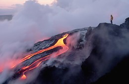
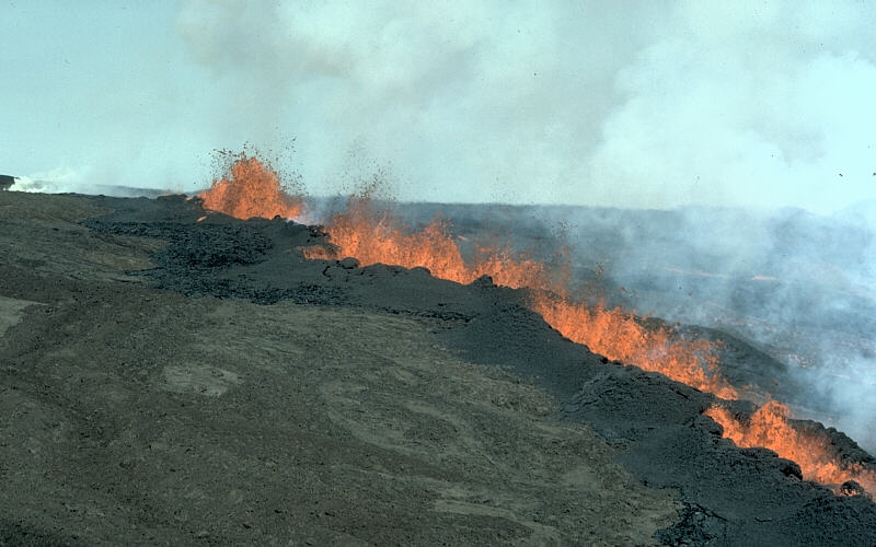
 feeding several active lava flows in the evening of 16 June. (Photo: Tom Pfeiffer)")
External volcanism: Lava flows from erupting vent of Mount Etna, Italy.
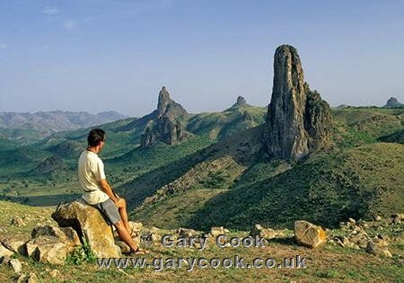
Volcanic plugs: near Rhumsiki, Cameroon.
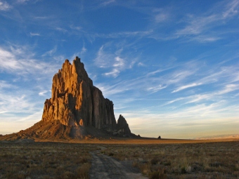
Giant volcanic plug with radiating dikes: Ship Rock, New Mexico.
. It lies along the crest of the Sierra Nevada mountain range. Composed of the Sierra Nevada batholith granite formation, its eastern side (seen here) is quite steep. It is climbed by hundreds of hikers each year., natural history stock photograph, photo id 21760")
Batholith: Sierra Nevada Batholith granite formation includes Mount Whitney, California.
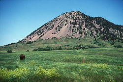
Laccolith: Bear Butte State Park, South Dakota.
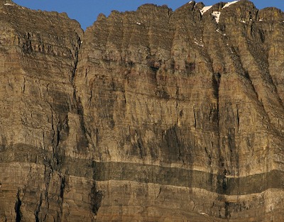
Sill: Mount Gould, Montana.
.jpg)
Parallel Dikes: Cross-Island Trail, Alaska
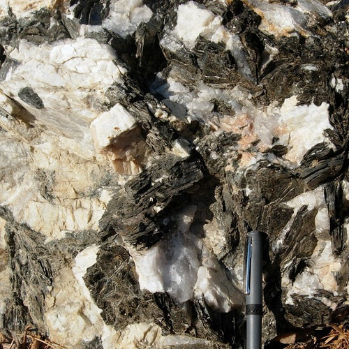
Pegmatite.
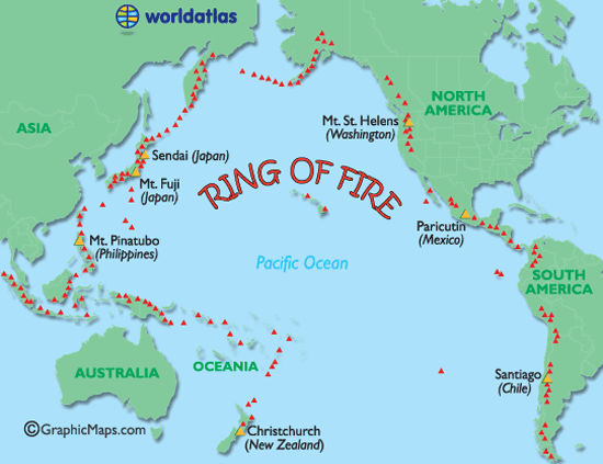
Pacific Ring of Fire: Some 450 volcanos define the boundaries of the Pacific Plate, producing 90% of the world's earthquakes and 75% of its active volcanos.
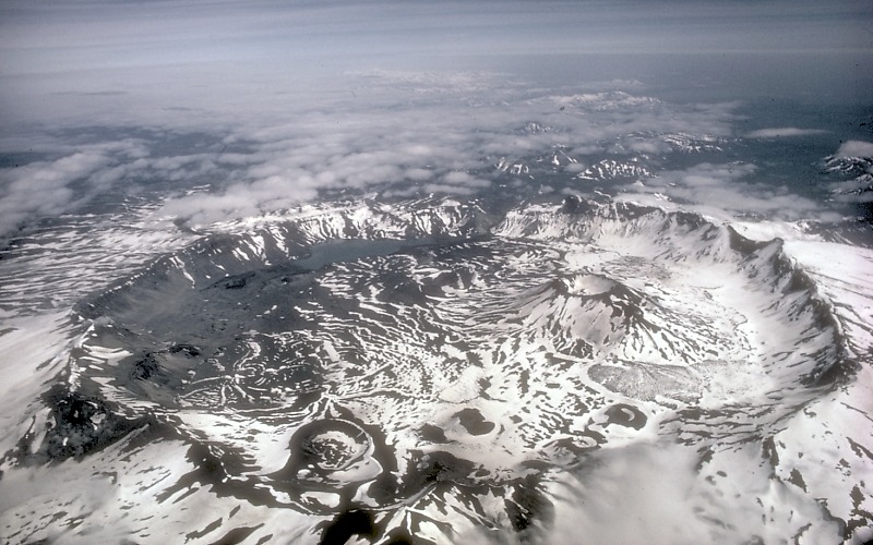
Caldera: Aniakchak Caldera, Alaska.
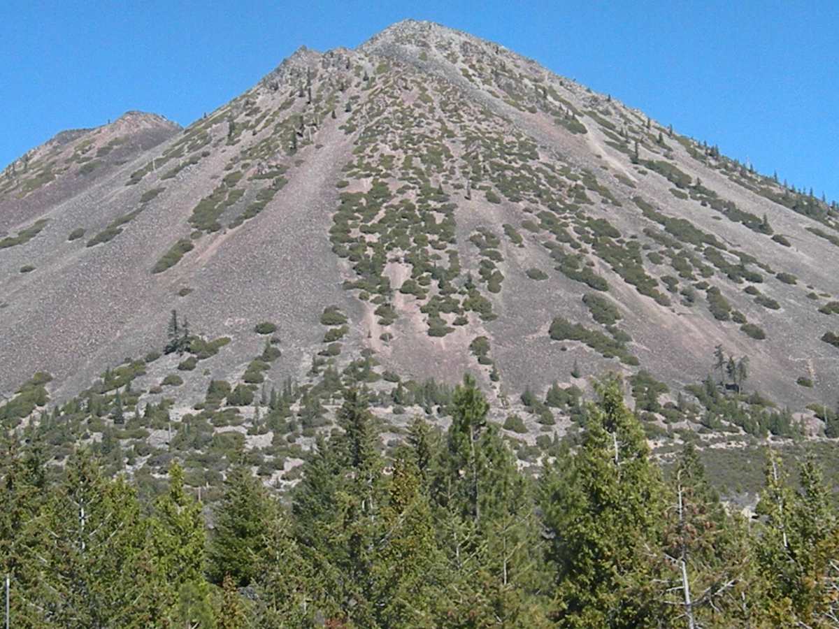
Cinder cone: Mt. Shasta, California.
Shield cone: Mauna Loa, Hawaii.
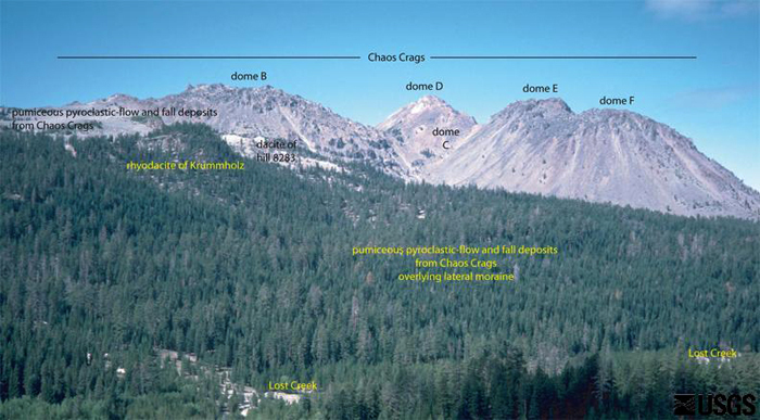
Dome cone: Lassen Volcanic Center, California.
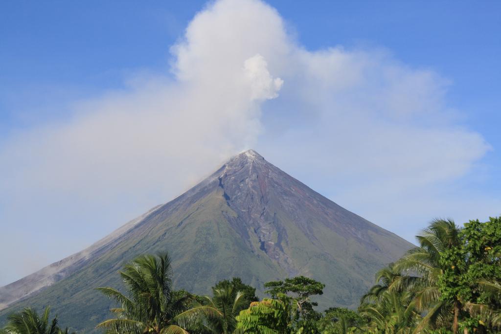
Composite or strata cone: Mount Mayon, Philippines.
Fissure flow: Mauna Lao Volcano, Hawaii.
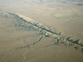
San Andreas Fault at Carrizo Plain, 100 miles north of Los Angeles, California.
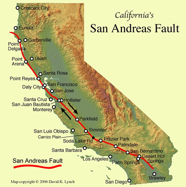
Map of San Andreas Fault, California.
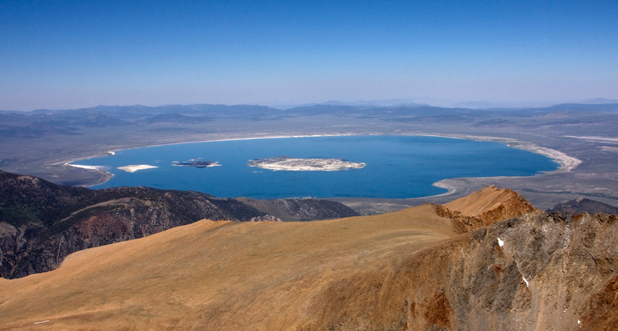
Mono Lake, California.