A megathrust quake like Alaska’s 9.2 will hit Seattle
More Recent Stories
- U.S. MILITARY WARNS OF PLOT BY FEDERAL RESERVE BANKERS TO HAVE CIA MERCENARIES FROM LIBYA KILL NEW YORK COPS
- April 29, 2024 : UPDATE TO FOURWINDS READERS
- AMERICA HASN'T LEARNED A THING: Racism, Materialism and Militarism Still Reign Supreme
- UPDATE: TO FOURWINDS READERS January 13 2023
- A PRAYER FOR AMERICA
Help Us Grow
Like Us On Facebook and Follow Our Posts
Most Emailed
Jake Ellison
The devastating megathrust earthquake that struck Alaska 50 years ago Thursday is a pretty good indication of what’s in store for Seattle and the upper regions of the West Coast when the Cascadia Subduction Zone lets one fly.
And we all thought the 6.8 Nisqually earthquake of 2001 was big … well look at these photos from the 9.2 magnitude Alaskan megathrust quake:
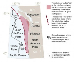
 (Click for larger version) THE CASCADIA SUBDUCTION ZONE: The North American Plate collides with a number
On the 314-year anniversary of the last one, the Cascadia Region Earthquake Workgroup published an updated scenario document for what that magnitude of quake would do to us now. The group said in a news release:
“Cascadia’s last great earthquake occurred on January 26, 1700 and ‹stresses have been building on the fault ever since. While the full extent of the earthquake hazard was not realized until the 1980s, the Cascadia subduction zone is now one of the most closely studied and monitored regions in the world.”
And no wonder.
As we wrote in June, the Cascadia Subduction Zone running the length of the coast from northern Vancouver Island down to California last slipped and shook the surface of the Earth 300 years ago, and that was just the latest of 22 such quakes in the past 11,000 years.
The Alaska megathrust “lasted approximately 4.5 minutes and is the most powerful recorded earthquake in U.S. history. It is also the second largest earthquake ever recorded, next to the M9.5 earthquake in Chile in 1960,” reports the USGS.
That agency has put together a bunch of information around that quake under the title: The Great Alaska Earthquake and Tsunami of March 27, 1964.
That quake’s damage was severe:
- The area where there was significant damage covered about 130,000 square kilometers (about 50 square miles). The area in which it was felt was about 1,300,000 square kilometers (502,000 square miles, or all of Alaska, parts of Canada, and south to Washington).
- The four-minute duration of shaking triggered many landslides and avalanches. Major structural damage occurred in many of the major cities in Alaska. The damage totaled $300-400 million (in 1964 dollars).
- The number of deaths from the earthquake totaled 131 — 115 in Alaska and 16 in Oregon and California.
- The death toll was extremely small for a quake of this magnitude due to low population density, the time of day and the fact that it was a holiday, and the type of material used to construct many buildings (wood).
- Much of the damage and most of the lives lost were due to the effects of water waves. These were mainly of two kinds: The tsunami of open-ocean sea wave, generated by large-scale motion of the sea floor; and the local wave, generated by underwater landslides in bays or fiords.
- The 1964 Alaska tsunami was the second-largest ever recorded, again following only the one caused by the 1960 Chile earthquake (4 meters, more than 12 feet, at Sitka). Of the 119 deaths attributable to the effects of the ocean, about one-third were due to the open-ocean tsunami: four at Newport Beach, Ore.; 12 at Crescent City, Calif.; and about 21 in Alaska.
Video: This USGS recount of the quake is great and will give you all you need to know. (There is a longer version here and a fact sheet pdf has been added below.)
