

TRIPLE SWARM OF EARTHQUAKES SHAKES YELLOWSTONE
KOMO News
JACKSON, Wyo. (AP) — Until recently, Bob Smith had never witnessed two simultaneous earthquake swarms in his 53 years of monitoring seismic activity in and around the Yellowstone Caldera.
Now, Smith, a University of Utah geophysics professor, has seen three swarms at once.
"It's very remarkable," Smith said. "How does one swarm relate to another? Can one swarm trigger another and vice versa?"
Because concurrent swarms have never been detected in the past, the answers aren't in yet, Smith said. The geophysicist said he "wouldn't doubt" if at least two of the events were related.
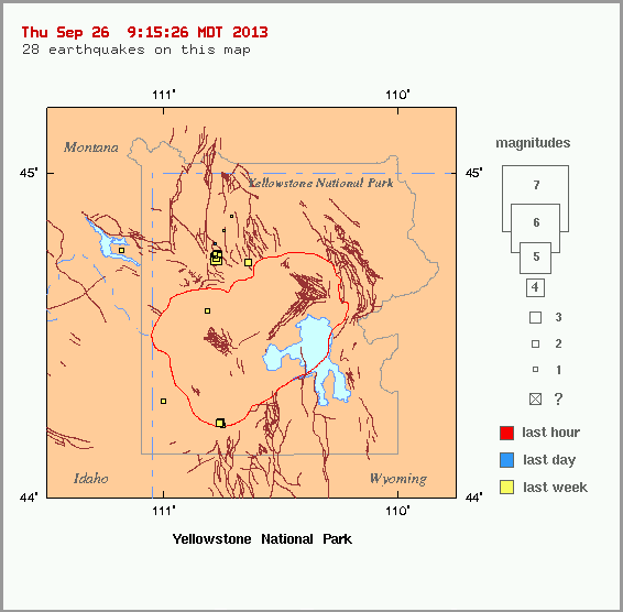
Temblors from the three quake swarms mostly hit in three areas: Lewis Lake, the Lower Geyser Basin and the northwest part of Norris Geyser Basin.
The largest earthquake shook the ground near Old Faithful Geyser on Sept. 15.
The epicenter of the magnitude 3.6 quake, the largest in Yellowstone in about a year, was just 6 miles to the north of Old Faithful.
The largest of the quakes shook the ground near Old Faithful Geyser.
"Generally speaking it needs to be 3.0 or higher for individuals to feel it," Yellowstone National Park spokesman Al Nash told the Jackson Hole News & Guide. "This one was somewhat stronger than that and it was in an area where a lot of people are."
Yellowstone's recent earthquake swarms started on Sept. 10 and were shaking until about 11:30 a.m. Sept. 16.
"A total of 130 earthquakes of magnitude 0.6 to 3.6 have occurred in these three areas, however, most have occurred in the Lower Geyser Basin," a University of Utah statement said. "Notably much of seismicity in Yellowstone occurs as swarms."
Including smaller events that have not been verified, there were many more quakes, Smith said.
The recent swarms produced roughly four quakes that were large enough to feel.
The first, a magnitude 3.5, struck Sept. 13 about 17 miles northeast of West Yellowstone, Mont. Then, in the early hours Sept. 15, two quakes, a magnitude 3.2 and magnitude 3.4, were detected in quick succession at 5:10 and 5:11 a.m., about 15 miles southeast of West Yellowstone. The magnitude 3.6 that marked the peak of the swarm struck nearby about 4 1/2 hours later.
"They weren't big earthquakes," Smith said, "but they were felt."
About half a dozen earthquakes are felt in Yellowstone in an average year, he said.
"This is pretty unusual, to be honest," Smith said.
None of the recent quakes, Nash said, were strong enough to cause damage or throw off the cycle of the Old Faithful geyser's eruptions.
"We know that a significant enough earthquake in the region has potential to alter geyser activity," the spokesman said. "A strong enough earthquake, like the one that occurred out at Hebgen Lake in 1959, did change the interval of Old Faithful eruptions."
That quake, a 7.3 to 7.5 on the Richter magnitude scale, caused nearly 300 features on the Yellowstone landscape to erupt, 160 of which had no previous record of geysers.
Smith traced the three recent earthquake swarms to the Hebgen Lake quake.
"These are a really related," he said.
"We think that much of the seismicity is still aftershocks from that event in 1959. It can go on for hundreds of years."
http://www.komonews.com/news/national/Swarm-of-earthquakes-shakes-Yellowstone-224773612.html
*************
Click on an earthquake on the above map (or in the list below) for more information.
Click here to go to index map || big earthquake list || all earthquakes list
Special maps: Yellowstone National Park || ANSS Intermountain West Region
Map need updating? Try reloading the page to your browser.
Maps are updated within about 5 minutes of an earthquake or once an hour.
Brown lines represent known hazardous faults or fault zones. White lines are roads.
Update time = Thu Sep 26 9:15:26 MDT 2013
Here are the earthquakes appearing on this map, most recent at top ...
 MAG    DATE    LOCAL-TIME  LAT     LON    DEPTH    LOCATION
        y/m/d     h:m:s     deg     deg     km
 0.5  2013/09/25 15:21:24 44.781N 110.783W  2.0   29 km (18 mi) ENE of  West Yellowstone, MT
 1.5  2013/09/24 23:13:24 44.749N 110.783W  8.2   27 km (17 mi) ENE of  West Yellowstone, MT
 0.8  2013/09/24 20:59:28 44.741N 110.780W  2.3   27 km (17 mi) ENE of  West Yellowstone, MT
 0.8  2013/09/24 19:33:20 44.741N 110.783W  2.9   27 km (17 mi) ENE of  West Yellowstone, MT
 1.2  2013/09/24 18:53:57 44.746N 110.766W  9.3   28 km (18 mi) ENE of  West Yellowstone, MT
 2.4  2013/09/24 18:48:32 44.737N 110.780W  6.4   27 km (17 mi) ENE of  West Yellowstone, MT
 0.4  2013/09/24 07:42:07 44.743N 110.782W  3.9   27 km (17 mi) ENE of  West Yellowstone, MT
 0.3  2013/09/24 07:35:06 44.738N 110.778W  3.5   27 km (17 mi) ENE of  West Yellowstone, MT
 1.4  2013/09/24 07:29:35 44.745N 110.771W  7.7   28 km (17 mi) ENE of  West Yellowstone, MT
 0.5  2013/09/24 07:05:01 44.742N 110.779W  2.6   27 km (17 mi) ENE of  West Yellowstone, MT
 0.9  2013/09/24 05:31:02 44.740N 110.782W  5.4   27 km (17 mi) ENE of  West Yellowstone, MT
 1.3  2013/09/24 04:52:47 44.739N 110.779W  2.3   27 km (17 mi) ENE of  West Yellowstone, MT
 1.2  2013/09/24 04:48:57 44.745N 110.786W  4.9   27 km (17 mi) ENE of  West Yellowstone, MT
 0.4  2013/09/24 04:48:21 44.736N 110.781W  3.1   27 km (17 mi) ENE of  West Yellowstone, MT
 1.2  2013/09/24 04:37:24 44.751N 110.766W  9.7   29 km (18 mi) ENE of  West Yellowstone, MT
 2.4  2013/09/24 04:32:27 44.749N 110.773W  7.9   28 km (17 mi) ENE of  West Yellowstone, MT
 1.5  2013/09/24 04:31:27 44.751N 110.776W  7.1   28 km (17 mi) ENE of  West Yellowstone, MT
 3.2  2013/09/24 04:24:24 44.734N 110.776W  5.3   27 km (17 mi) ENE of  West Yellowstone, MT
 0.3  2013/09/23 06:41:33 44.864N 110.710W 17.9   19 km (12 mi) S   of  Gardiner, MT
 1.8  2013/09/23 04:57:38 44.300N 111.001W 12.1   33 km (20 mi) NE  of  Warm River, ID
 0.9  2013/09/23 02:51:19 44.820N 110.747W  5.2   24 km (15 mi) S   of  Gardiner, MT
 2.7  2013/09/23 02:32:50 44.232N 110.763W  5.1   46 km (29 mi) ENE of  Warm River, ID
 2.0  2013/09/23 02:30:21 44.234N 110.760W  4.4   46 km (29 mi) ENE of  Warm River, ID
 1.4  2013/09/23 02:29:48 44.223N 110.751W  2.3   47 km (29 mi) ENE of  Warm River, ID
 1.6  2013/09/21 22:37:26 44.748N 110.778W  9.0   28 km (17 mi) ENE of  West Yellowstone, MT
 1.1  2013/09/21 00:58:58 44.759N 111.185W 12.3   12 km ( 8 mi) NNW of  West Yellowstone, MT
 1.1  2013/09/20 14:00:57 44.573N 110.817W  6.2   25 km (15 mi) ESE of  West Yellowstone, MT
 2.0  2013/09/19 23:57:37 44.724N 110.644W  5.5   35 km (22 mi) S   of  Gardiner, MT
Utah Region + Yellowstone National Park Region = University of Utah Seismograph Stations
a member of the Advanced National Seismic System (ANSS)
http://www.seis.utah.edu/req2webdir/recenteqs/Maps/Yellowstone.html