
MT. RAINIER: IMMINENT THREAT TO MILLIONS OF AMERICANS
CREATOR GOD ATON/HATONN/ Rocky Montana
R. Montana / 9-2-2013
In a most important message of September 30, 1989, Father Aton named both Mt. St. Helens and Mt. Rainier as being imminent threats to humans living in the vicinity of those two volcanos.Quoting:... Who will then tend when the volcanos erupt? Your native brothers tell you truth; the signs are always brought forth for you and then you turn and do such foolish things.
Let us just consider your state of Washington for a minute. Your elder brothers of the ancients told you that the "Little Sister" would weep and speak unto you ones. And then, the "Grandfather" mountain would speak! Mt. St. Helens spoke--your little sister spoke loudly and some heard and most plugged their ears. The grandfather rumbles and that, dear ones, is Mt. Rainier. How many have been lured unto its very regions by the evil teachers who bring destruction and evil shrouded in partial truth? How many will perish in their ignorance and blame the God in heaven for your foolishness? You were given "reason" and you heed it not.
End quoting.
* * *
Mount St. Helens ("Little Sister") -- Lessons Learned (?)
Mount St. Helens the day before the 1980 eruption.

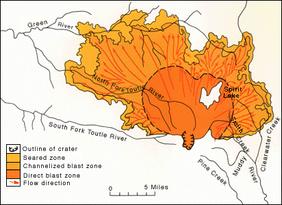
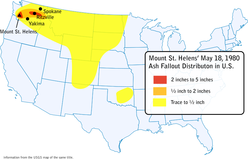
Mount St. Helens is an active stratovolcano located in Skamania County, Washington, in the Pacific Northwest region of the United States. It is 96 miles (154 km) south of Seattle, Washington and 50 miles (80 km) northeast of Portland, Oregon. On Sunday, May 18, 1980, at 8:32:17 A.M. PDT, a 5.1 magnitude earthquake triggered the Mount. St. Helen's entire weakened north face to slide away, suddenly exposing the partly molten, gas and steam-rich rock in the volcano to lower pressure. The rock responded by exploding a hot mix of lava and pulverized older rock toward Spirit Lake (northeast of the volcano) so fast that it overtook the avalanching north face. The lateral blast of rock, ash, and hot gases devastated an area of about 230 square miles in a fan-shaped sector north of the volcano. At the same time, snow, ice and several entire glaciers on the volcano melted, forming a series of large lahars (volcanic mudflows) that reached as far as the Columbia River, nearly 50 miles to the southwest. Prior to the eruption, 11 major glaciers and 2 minor glaciers radiated down the flanks of the volcano along with numerous perennial snowfields. The cataclysmic eruption and landslide on May 18, 1980, largely destroyed the glaciers that had existed, removing about 70% of the volcano's glacier mass. Hundreds of square miles were reduced to wasteland. The towering plume of sulfuric steam, gases, smoke and ash rose 80,000 feet into the atmosphere and laid down an elliptical blanket of caustic sulfuric ash perpendicular to the volcano to the east. Between .5 inch and 5 inch of ash was laid down all the way to the eastern border of Washington. Traces of ash deposits were observed in 11 U.S. states, as far away as Oklahoma. A second eruption occurred on May 25th but was relatively mild in comparison to the May 18th eruption.
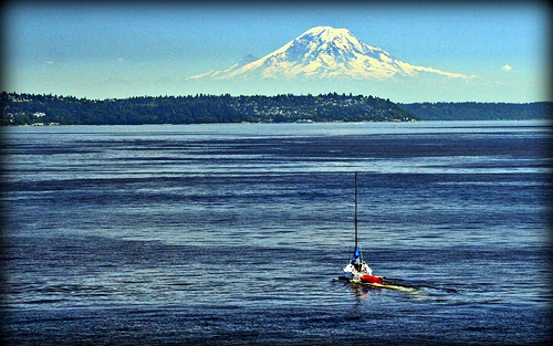
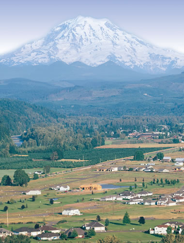
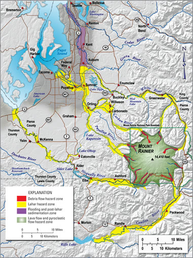
Generalized map showing the lateral blast zone.Mother Nature was kind to humankind that fateful day. Had the eruption been directed southwest and the winds blown from the northeast, Portland, Oregon would have felt the effects of the blast, lahars and ash fallout. Due to number of favorable weather and geological conditions the impact to humans was kept to a minimum. These conditions included the following facts: Prior warnings were given off by the volcano which called the entire region to be on alert, the direction of the lateral blast and lahars were directed away from dense population centers in a northerly direction, the major ash fallout was also directed away from dense population centers in an easterly direction, and the efforts of U.S.G.S. and Park authorities in both forecasting warnings, calling for evacuation of residents, and restricting further access to the area kept sightseers and passers-by to a minimum. Considering the magnitude and area covered by the eruption, the lahars and the ash fallout deposits, relatively few people perished in this horrific geological event. 57 people, perished. Included among the lost were scientists, loggers, tourists and sightseers, including geologist David Johnston and one rather stubborn 83-year-old individual, Harry R. Truman. In addition 47 bridges, 15 miles (24 km) of railways, and 185 miles (298 km) of highway were destroyed placing property damage over a billion U.S. dollars (more than $2.74 billion in 2013 dollars).Since May 1980 a lava dome has been building ominously near the center of the massive Mount St. Helens crater and steam is occasionally seen venting from this lava dome, a signal that there are still powerful forces building just below the surface. This should be viewed as a warning to all that Mt. St. Helens is still an active volcano which could erupt again given the right conditions.Lava dome building near the center ofthe Mt. St. Helens' crater.3,000 ft (1 km) steam plume onMay 19, 1982, two years after itsmajor eruption.* * *Mount Rainier ("Grandfather") -- Ticking Time Bomb!The Mount Rainier range is an awesome colossal natural wonder in the beautiful Cascade Mountains and on a clear day can be seen 100 miles away in all directions. The highest peak in the Cascade Range, this massive volcano towers 14,410 ft in elevation, dwarfing Mount. St. Helens by 4,650 ft. (pre-eruption height). Mount Rainier is located 54 miles (87 km) southeast of Seattle Washington. The Greater Seattle/Tacoma Area to the Northwest/West has an estimated population of over 3,707,400 people (2010 census). Despite its wondrous beauty, Mount Rainier is a massive, active, stratovolcano and is listed as the most potentially deadly volcano in the western United States due to its sheer size and proximity to human population centers, mostly to the west along the Pacific coast. During an eruption approximately 5,000 years ago the once-higher edifice collapsed to form a large crater open to the northeast much like that of the Mount St. Helens eruption of 33 years ago. Ensuing eruptions rebuilt the summit, filling the large collapsed crater. Large lahars originating from prior eruptions and collapses of this massive, heavily glaciated volcano have reached as far west as the Puget Sound lowlands approximately 30 miles away.But for all its natural beauty, those who continue to live within the reach of Mount Rainier's potentially deadly forces must treat this volcano with the respect it deserves and keep an ever-watchful eye on it. For one day, perhaps sooner than anyone expects, Mount Rainer may erupt with devastating force. Anyone caught within its eruption blast zone and destruction path will surely perish. If this volcano were to erupt as powerfully as Mount St. Helens did in 1980, the effect would be cumulatively greater, because of the far more massive amounts of glacial ice -- 26 major glaciers in all, nearly 2.5 times the amount of pre-eruption glaciers of Mount St. Helens -- that radiate down its flanks and the massive amounts of perennial snows that cling to the mountain, as well as the vastly more heavily populated areas surrounding this colossal volcano.Puget Sound and Mt. Rainier in the background.Signals The first signal will be an earthquake, possibly 5.0 or greater. This should prompt ones to be on alert. If there is time verify the magnitude of the earthquake with U.S.G.S. on-line or listen for radio/TV reports. The second signal is a loud sound like a bomb blast that should be heard for 50 miles from Mount Rainier. This is the volcano eruption. Pray that you only hear the blast and cannot see it; this means that the volcano eruption blast occurred in a direction away from you. Pray also that it is a clear day so that you can observe the volcano. There may be seconds or minutes or even hours between the earthquake and the volcanic eruption. The third signal is the plume above the volcano, indicating a volcanic eruption. The larger and higher the plume gets, the larger the eruption is. You don't need anymore confirmation than these three signals to know that there has been a major volcanic eruption. If I felt an earthquake in the region around Mount Rainier and heard a loud blast I, personally, would not wait around for any more signals. I would immediately stop what I was doing and put my evacuation plan into action.Lahars Lahars, like water, travel down the path of least resistance -- originating either from the eruption site or from the tremor of the volcano on onw of its faces. These bodies of liquid and material snowballs while gaining speed down the mountain side and cascades into the nearest low-lying area they comes to. They can consist any combination of the following: lava, pyroplastic flows, ice, snow, water, rock, soil, mud and vegetation, and will pick up and practically anything in their flow path. They form enormous liquid and debris flows which can travel tens of meters per second, be 140 meters (460 ft) deep, rage for up to 100 miles along low-lying valleys, streams and rivers, and will destroy anything in their path. Suffice to say, you don't want to be in their path.Sulfuric ash fallout Ash fallout from a volcanic plume, as in the Mount St. Helens eruption, can be carried by the prevailing winds to perhaps 300 miles or more and can lay down anywhere from .5 to 5 inches of sulfuric ash and dust. This ash fallout will eventually render most internal combustion vehicles inoperative and create a dead zone for all biological life for months and even years to come. During an ash fallout the sulfuric gases, dust and ash displace much of the oxygen needed by biological organisms to survive. Moreover, breathing in sulfuric ash is potentially deadly as the ash mixes with moisture in the mouth and lungs, creating a cementitious paste which clings to the lung walls and if exposed for an extended period can completely shut down lung function, resulting in death by suffocation. For these reasons, it is critical to escape this dead zone as soon as possible. For most of the year the prevailing winds in the Greater Seattle/Tacoma area generally blow in a southerly direction, except in August and September when they reverse direction and blow to the north.Moving out of harms wayInhabitants of this region and live within 50-60 miles of this volcano should be on constant alert and be prepared for the inevitable. For those ones who have not prepared, the time is now. The best choice from a life-safety standpoint is to move far enough away from this volcano in order to be free from a major eruption, the lahars and the ash fallout. Because exact locations of these disaster zones cannot be predetermined, I, personally, would not live closer than 60 miles from Mount Rainer and especially would not live in a valley within that same radius. A 60 radius should give enough space to observe the volcano and possible eruption from a good distance and make some sound decisions. If you were downwind and saw the ash fallout coming your way, for instance, you might want to bug-out to another location until the fallout stopped.Ones who, for one reason or another, cannot or will not move from their present location from out of the radius of potential destruction, which I expect is the majority of the population, will have an infinitely more difficult time surviving a Mount Rainier eruption and subsequent devastation. The reason for this is in the numbers of people who will all be running for their lives at the same time and in the same direction, all frantically trying to fly, drive, bicycle or run from harms way, thus clogging the airports, streets, highways and freeways. Ones who wait until this disaster occurs without taking precautions ahead of time will have a difficult time surviving if caught in the damage path. Remember, an earthquake of 5.1 triggered the Mount St. Helens eruption. A review the movie Dante's Peak should drive home the benefit of both living far enough away from this ticking time bomb, Mount Rainier, and the need to devise, practice, and perfect an early warning evacuation plan.Preparation and Evacuation The following are some additional common-sense precautions that can be taken now -- before its too late. The billowing volcanic plume resulting from a Mount Rainier eruption may lay down an approx. 300 mile-long by 50 miles wide elliptical blanket of ash from 2 to 5 inches thick over the downwind countryside. Ones caught in such an ash plume and ash fallout zone will find it difficult to breathe without some sort of a filtering device which will require changing of filters in a timely manner in order to be affective. Therefore, invest in a dual-filter respirator for each family member with several pairs of replaceable filters that filter-out both sulfuric gas and particulate. An investment of goggles will also pay off. These two tools alone may just save your life. Put these in your 72 hour kit. All internal combustion engines (cars, trucks, motorcycles, RV's, tractors, busses, etc. all have air filters. They will also stall if the air filters are not changed in a timely manner. Therefore, purchase and have handy several additional air filters for your vehicle and know how to replace them quickly. For the same reason all aircraft within the ash plume will be grounded so don't expect this avenue of escape to be available. Those who have not evacuated early by automobile, train or airplane may be caught without an operating vehicle and forced to walk, run or bicycle out of the deadly ash storm. Purchase a mountain bicycle for each family member as a means of transportation of last resort.If you haven't already done so, purchase a 72 hour kit, preferably a backpack type, for each family member ready to go at a moment's notice. Stock it with adequate water and MRE's and a portable radio and other things you will need for a least 3 days. Stay on constant alert for volcanic activity. Plan a number of evacuation routes and destinations that are far enough out of harm's way. Make a list of safe and desirable bug-out locations along your evacuation routes such as camping grounds, motels, friends or family members homes, etc. Coordinate these evacuation plans with your family members. Every family member should know what to do and where to meet-up if separated, ahead of time as cell phones may not work for hours or even days following the event. Make other plans and take other precautions that come to mind for your survival now before a volcanic eruption occurs. Ones caught in valleys or low-lying areas within a 60 mile radius of an erupting volcano should immediately move out of the valleys and seek higher ground to avoid deadly lahars. Heed these and other warnings and safety precautions that safety authorities may be giving over the radio or television.Conclusion Having a disaster evacuation plan and the ability to think clearly in a disaster is paramount. The more prepared ones are for this geological event discussed in the preceding paragraphs, or for any type of emergency for that matter, the calmer and clear thinking the individual will be and will know what to do. You are putting fear aside and taking control of the situation. This prepared state of mind will provide the mental conditioning needed to receive perhaps other guideance that will get you and your family to safety and survive the ordeal. I hope that all within reach of this writing will take this writing seriously and Godspeed.Quoting:I urge you to call upon these Masters of Life Truth for they stand ready to respond and most diligently acting presently and without rest that you shall be able to survive. They petition constantly in your behalf for mercy. It no longer is a matter of mercy, it is now a matter of "justness" --what ye ones have sowed and nurtured, so shall ye reap. It is never too late to return to Truth and petition for thy being but YOU shall do of it, for no one--not even the Greatest of the Masters--can do of it for you. YOU MUST DO IT FOR YOURSELF! I AWAIT YOUR CALL!
I AM THAT I AM.
I AM ATON--YOUR SOURCE.
End quoting.