Hudson volcano eruption (Chile) – Red Alert : Eruption is subsiding + live webcam
Armand Vervaeck
Initial comment : Cerro Hudson volcano, a Southern Andean volcano located in the border area in between Chile and Argentina (click here to see the map) has started a minor eruption.
SERNAGEOMIN, the Chilean authority who is guarding the activity of the volcanoes has increased the alert level from 3 to 5 (Red Alert). Onemi, the Chile government organization who is coordinating all actions to protect people and infrastructure from being damages /injured has called the RED alert for the following localities : Aysén, Río Ibáñez and Chile Chico in the Aysén area.
Both organizations will of course follow up the situation of Cerro Hudson 24 hours on 24 and 7 days on 7. Due to the remote location of this volcano, the reporting from the eruptions will be far less than it was the case with the Puyehue – Cordón Caulle

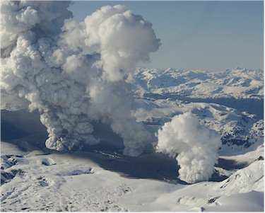
3 erupting craters of the of the Hudson volcano, Chile - picture courtesy and copyright El Mercurio and Sernageomin, Chile
Update November 1 – 13:59 UTC
ONEMI Chile has reported yesterday evening that the internal as well as external activity of the Hudson volcano has subsided. Soon after they stressed that this NOT mean that all danger has gone. This might be only a temporary condition and thus the RED ALERT is maintained until further notice.
- the eruption cloud was observed at a height of 2000 to 2500 meter, less than our earlier report
Update October 31 – 13:59 UTC
A monitoring carried out by Onemi this morning at 09:30 local time (11:30 UTC) resulted in the following report :
- Las Malvas area : ashfall was observed within the volcanic cone area
- Mixed steam / gas smoking craters (white to grey)
- Yesterday evening, the level of the Rio Ibañez did increase by 30 cm. This morning the level was back to normal.
- seismic activity has increased seriously today compared to yesterday. This morning in between 04:00 and 06:00, 2 volcanic earthquakes per hour where noticed (yesterday : less than 1 per hour). Harmonic tremor was also present
- The coastal area was too cloudy to make good observations
- The number of evacuees has increased to 140 from the original 119. Police was able to trace 21 people still present in the 45 km NO GO radius zone and could evacuate them safely.
- All the ports and airports in the area remain open for operations
- Cattle owners are allowed to enter the 45 km radius to feed their animals on the condition that they agree to return immediately if ordered to.
Update October 29 – 16:49
We are sorry for the delay, but we have a hard time following the earthquakes and volcanoes at the same time.
SERNAGEOMIN has reported in a new report published yesterday afternoon (local time) that the volcano was less active than the day before.
- approx. 1 seismic event per hour. Most earthquakes recorded were of the Long Period (LP), with magnitudes (ML) less than 2.2
- There were no explosive events
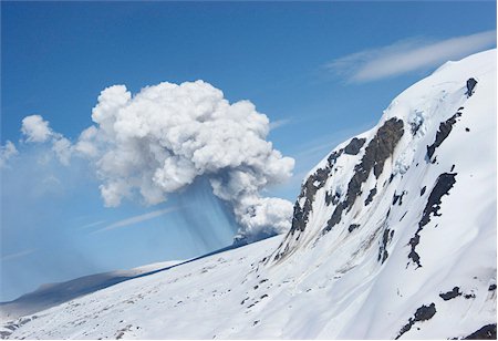
- Sernageomin staff and officials overflying the area have detected a steam/gases column with very little ash at a height of approx. 3-4 km
- NO lahar has been seen and the flow of the river Huemules decreased significantly compared to the previous day.
- All this indicates that although the number of earthquakes has decreased significantly, the process continues.
- In consideration of the current characteristics of the eruption the exclusion zone remains at 45 km radius around the crater.
Update October 28 – 14:24
In a report published at Buenos Aires at 13:30 yesterday (16:30 UTC), the regional VAAC (Volcanic Ash Advisory Committee) has confirmed a gas/steam column with low ash content above the Hudson volcano. The eruption cloud was observed between 1000 to 4000 m height. There was no sign outpouring of lava.
Update October 28 – 12:59 UTC :
- Images taken during flights from emergency agencies, SERNAGEOMIN staff and local authorities revealed the presence of three (3) craters located on the southern edge – southeast of the caldera with approximate diameters of 300, 200 and 500 meters. 2 of the craters were emitting mostly white steam/gas columns, the third (largest) crater was emitting a combination of ash and steam/gases to a max. height of 5.5 km. Satellite images have measured the plume to be 12 km in length.
- The OMI website discovered a sulfur dioxide concentration around the volcano at 16:00 local time.
Update October 28 – 12:56 UTC :
- In consideration of the current characteristics of the eruption, an exclusion zone of 45 km radius around the crater has been set.
- SERNAGEOMIN has calculated with their theorectical models that an eruption column of 10 to 16 km will lead to considerable ashfall to the North East (Friday and Saturday).
Update October 28 – 12:14 UTC :
- The spokesperson from HydroAysen have denied that an eventual major eruption of Hudson volcano would affect the hydro-electric project. He said that an in-depth risk study has confirmed that the potential risk has to be labelled “low” or “very low”. The project is using the waters of the Baker and Pascua rivers (ER : Onemi indicated yesterday that only the rivers Cupquelan and Huemules our labelled as dangerous for Lahars).
- The DGA (Dirección General de Aguas) has said that the water quality of the río Ibáñez remains good. The quality is permanently surveyed as the waters from this river are used to tap drinking water for the area.
- The Chilean authorities have 500 army personnel in the volcano zone to help with evacuations and many other tasks if needed. The troops have 24 trucks and 1 helicopter at their disposal.
Volcano data
- The most significant event occurred at 2:27 local time, with a local magnitude (ML) of 3.6. It was located in the southwestern edge of the caldera. As for the earthquakes related to fluid dynamics, occurred at 1:56 local time, an event of very low frequency (VLP) with a magnitude (ML) of 3.1 and a maximum reduced displacement (DR) of 566 cm2, which is considered high, possibly related to magma movement.
- There were no explosive events or episodes of high intensity harmonic tremor.
- Stability in the activity with a record of approximately five (5) events / hour (VT, HB, LP) between 16:00 hours (October 26) and 16:00 hours (October 27). Most earthquakes recorded were of the Volcano – Tectonic (VT), with magnitudes (ML) lower than 3.6, located west of the caldera, with depths between 3 and 25 km, with a tendency to become shallower.
ONEMI update October 27 – 18:51 UTC :
There are now three steam vents on the volcano. One of the vents is also emitting ash. The 3 vents are approx. 500 meter from each other (triangular form). This was observed this morning (Chile time) and was analyzed by SERNAGEOMIN technical staff.
119 people are currently evacuated from the Lake Caro area and have moved to houses from relatives in the area. Chile police is trying to evacuate an additional 13 people. Onemi Chile has reported that until this morning nearly 900 volcanic earthquakes were noticed. Only a limited number were felt by the people living in the area. New FlyBy’s are planned later today to follow up what is happening. Onemi also told the press that they are ready to take whatever measures are necessary to control the situation. Emergency staff in the volcano area have been equipped with satellite phones.
Activity report October 26, 2011
Translation of the Sernageomin press statement by Earthquake-Report.com
The Red alert (Level 5) has been called by SernaGeomin out of fear that a major eruption could happen in the coming hours or days.
The Hudson volcano eruptions are characterized by eruptive columns of several km high.
The dispersion of this material in the atmosphere could affect localities to N, E and S of the volcano. Unlike most volcanoes in other regions of Chile, Aysen population centers are situated downwind of volcanic centers and therefore are highly likely to receive fall of pyroclastic material.
The huge quantities of ice in the caldera could eventually generate destructive lahars (volcanic mudflow), mainly affecting the river valleys of Cupquelan and Huemules, located to the NW of the volcano.
Pyroclastic flows could, depending on the magnitude, affect the immediate vicinity of the caldera (within a radius of 15 to 20 km),
SERNAGEOMIN staff and local authorities today conducted a flyby in Hudson Volcano, which could see a column of gas, white and with little ash, about 1.5 km in height, with the subsequent formation of the Rio Huemules lahars. Erupting lava has not been seen. We have to state however that during the 1973 eruption a subglacial eruption occurred. This suggests a process of fissure opening at shallow levels and the onset of an eruptive process that is still minor but can evolve into a major eruption in hours and / or days.
A set of pictures taken during the flyBy can be seen here
Smithsonian Institute Volcano information : The ice-filled, 10-km-wide caldera of the remote Cerro Hudson volcano was not recognized until its first 20th-century eruption in 1971. Cerro Hudson is the southernmost volcano in the Chilean Andes related to subduction of the Nazca plate beneath the South American plate. The massive, 1905-m-high Cerro Hudson covers an area of 300 sq km. The compound caldera is drained through a breach on its NW rim, which has been the source of mudflows down the Río de Los Huemeles.
Two cinder cones occur north of the volcano and others occupy the SW and SE flanks. Hudson has been the source of several major Holocene explosive eruptions. An eruption about 6700 years ago was one of the largest known in the southern Andes during the Holocene; another eruption about 3600 years ago also produced more than 10 cu km of tephra. An eruption in 1991 was Chile’s second largest of the 20th century and formed a new 800-m-wide crater in the SW part of the caldera.
Wikipedia Informartion on Cerro Hudson :
Mount Hudson (locally known as Cerro Hudson) is a stratovolcano in southern Chile, and the site of one of the largest eruptions in the twentieth century. The mountain itself is covered by a glacier. There is a caldera at the summit from an ancient eruption; modern volcanic activity comes from inside the caldera. Mount Hudson is named after Francisco Hudson a 19th century Chilean Navy hydrographer.
Large eruptions around 4750 BCE and 1890 BCE are believed to have been of Volcanic Explosivity Index (VEI) 6; these are probably responsible for the large caldera. The 4750 BCE eruption may have wiped out many if not all groups of early man living in central Patagonia at that time, based on evidence from the Los Toldos archaeological site. Recently, the volcano has had moderate eruptions in 1891 and 1971 as well as a large eruption in 1991.
1971 eruption
Before 1970, little was known about the mountain. Minor eruptive activity began in 1970 and melted parts of the glacier, raising river water levels and leading to the identification of the caldera. In August-September 1971, a moderate eruption (VEI 3) located in the northwest area of the caldera sent ash into the air and caused lahars from the melting of a large portion of the glacier. The lahars killed five people; many more were evacuated.
1991 eruption
The eruption in August to October 1991 was a large plinian eruption with a VEI of 5, that ejected 4.3 km3 bulk volume (2.7 cubic km of dense rock equivalent material). Parts of the glacier melted and ran down the mountain as mud flows (see glacier run). Due to the remoteness of the area, no humans were killed but hundreds of people were evacuated from the vicinity. Ash fell on Chile and Argentina as well as in the South Atlantic Ocean and on the Falkland Islands.
In addition to the ash, a large amount of sulfur dioxide gas and aerosols were ejected in the eruption. These contributed to those already in the atmosphere from the even larger Mount Pinatubo eruption earlier in the year and helped cause a worldwide cooling effect over the following years. Ozone was also depleted, with the Antarctic ozone hole growing to its largest levels ever recorded in 1992 and 1993.
As a result of the Pinatubo eruption, the Hudson eruption received little attention at the time.
Original Press Statement Sernageomin Chile (Spanish) October 26, 2011
El Observatorio Volcanológico de los Andes del Sur (OVDAS), del Servicio Nacional de Geología y Minería (SERNAGEOMIN) – informa la actividad del volcán Hudson
Cambio de la alerta volcánica a NIVEL 5 – ROJO: Inminencia de una Erupción Mayor en horas / días.
El volcán Hudson se caracteriza por erupciones explosivas con columnas eruptivas de varios km de altura. La dispersión de este material en la atmósfera podría afectar localidades ubicadas al N, E y S del volcán. A diferencia de la mayoría de los volcanes ubicados en otras regiones de Chile, en Aysén los centros poblados están emplazados vientos abajo de los centros volcánicos y por lo tanto son altamente susceptibles de recibir caída de material piroclástico.
Dada la masa de hielo anidada en la caldera la generación de lahares ha sido conspicua durante las erupciones del volcán, afectando principalmente los valles de los ríos Huemules y Cupquelán, ubicados hacia el NW del volcán. Por otro lado la removilización de material no consolidado podría generar lahares secundarios en los valles donde se acumule caída de piroclastos (típicamente el valle del Río Ibáñez, hacia el SE del volcán).
Flujos piroclásticos podrían afectar las inmediaciones de la caldera, en un radio aproximado entre 15 – 20 km, dependiendo de la magnitud.
Después del enjambre sísmico ocurrido la madrugada del día miércoles 26 de octubre, personal de SERNAGEOMIN y autoridades locales realizaron hoy un sobrevuelo en el Volcán Hudson, en el cual se pudo observar una columna de gases, de color blanco y con poca ceniza, de aproximadamente 1,5 km de altura, con la subsecuente formación de lahares por el Río Huemule. No se pudo constatar la efusión de lava, pero hay que tener presente que en 1973 ocurrió una erupción subglacial (sin salida de material magmático) (Naranjo, com. personal).
Lo anterior indica un proceso de apertura del sistema a niveles superficiales y el inicio de un proceso eruptivo que aún es menor, el cual puede evolucionar en una erupción mayor en horas y/o días.
Nov. 1, 2011
VIEW VIDEO


