FourWinds10.com - Delivering Truth Around the World
Custom Search

Recent Earthquakes and Volcanic Activity

Steve Quayle

Smaller Font Larger Font RSS 2.0

Earthquake in Canary-Islands

Two new volcanic eruptions were confirmed on Wednesday near Spain's El Hierro island in the Canaries, where 500 people spent another night outside their homes after being evacuated as a precautionary measure. "I confirm the existence of two points of volcanic eruption at El Hierro," Laura Otero, a spokeswoman for the local authorities, told AFP, adding that there were dead fish and a strong odour of sulfur at both sites. The head of emergency services in the Canaries, Juan Manuel Santana, said in a statement that "the two points are located at two nautical miles and 1.5 miles southwest of (the village of) La Restinga". The first eruption occurred at a depth of 700 metres (2,300 feet) and the other at a depth of 200 metres (655 feet). He said the eruptions "resulted in two stains on the sea surface where there are dead fish and a strong odour of sulfur." Some 500 residents and tourists were evacuated from the village of La Restinga as a precautionary measure on Tuesday after a 4.3-magnitude quake the previous day, the first volcanic euption in the Canaries in 40 years. Monday's eruption was detected five kilometres (three miles) from the island at a depth of between 500 and 1,200 metres (1,640 and 3,940 feet) beneath the sea. Experts had said the eruption would not be felt on the island.

Most of the evacuees have found refuge with relatives or friends in other villages on the island. But dozens of others, mostly tourists, spent the night in a student dormitory and a local gym. Pointing to "uncertainty over the coming days", authorities said in a statement that they were keeping Restinga on "red alert", while the rest of the island remained on yellow alert, one notch lower. "It is recommended to exercise caution," said Paulino Rivero, head of the Canaries administration. But he said people would be able to return to their homes under the protection of civil safety officials to retrieve medicines or clothes. Rivero said scientists had noticed no significant changes since Tuesday afternoon. El Hierro, which means iron in Spanish, is the smallest of Spain's Canary Islands, located in the Atlantic off the coast of Morocco. Perched atop an ancient volcano, the island of Hierro has undergone some 10,000 tremors since July 19, the vast majority of them not felt by its 11,000 residents. The last volcanic eruption on the Canary Islands was on nearby La Palma in 1971.

****************

Volcano Activity in Iceland on Friday, 02 September, 2011 at 16:07 (04:07 PM) UTC.

If Iceland’s air-traffic paralyzing volcanic eruption last year seemed catastrophic, just wait for the sequel. That’s what some experts are saying as they nervously watch rumblings beneath a much more powerful Icelandic volcano - Katla - which could spew an ash cloud dwarfing the 2010 eruption that cost airlines $2 billion and drove home how vulnerable modern society is to the whims of nature. Brooding over rugged moss-covered hills on Iceland’s southern edge, Katla is a much bigger beast than the nearby Eyjafjallajokul volcano, which chugged ash all over Europe for several weeks in an eruption that local scientist Pall Einarsson describes nonetheless as “small.”

Named after an evil troll, Katla has a larger magma chamber than Eyjafjallajokul’s. Its last major eruption in 1918 continued more than a month, turning day into night, starving crops of sunlight and killing off some livestock. The eruption melted some of the ice-sheet covering Katla, flooding surrounding farmlands with a torrent of water that some accounts have said measured as wide as the Amazon. Now, clusters of small earthquakes are being detected around Katla, which means an eruption could be imminent, seismologists say. The earthquakes have been growing in strength, too. After a long period of magnitude 3 tremors, a magnitude 4 quake was detected last week. “It is definitely showing signs of restlessness,” said Einarsson, a professor of geophysics at the University of Iceland. Teams of seismologists and geologists at the university are tracking the spike in seismic activity and working with disaster officials to prepare communities near Katla like Vik, a small town of some 300 people that is flanked by black sand beaches.

Civil defense authorities have been holding regular meetings with scientists. Disaster officials have also drafted an evacuation plan and set aside temporary housing, but many fear they may have less than an hour to evacuate once the volcano erupts. Iceland sits on a large volcanic hot spot in the Atlantic’s mid-oceanic ridge. Eruptions, common throughout Iceland’s history, are often triggered by seismic activity when the Earth’s plates move and magma from deep underground pushes its way to the surface. The longer pressure builds up, the more catastrophic an eruption can be. Records show that Katla usually has a large eruption twice a century. Since its last eruption was almost exactly 93 years ago, it is long overdue for another, seismologists say. Icelanders are getting nervous as they mark the anniversary of Katla’s last blast.

“We’ve been getting calls recently from people concerned that Katla is about to erupt because it erupted ... in 1918 on Oct. 12,” said Einar Kjartansson, a geophysicist at the Icelandic Meteorological Office. “As scientists we don’t see that much of a correlation in the date but there is most definitely increased activity. The question is whether it calms down after this or whether there is an eruption.” The eruption of Laki in 1783 was one of Iceland’s deadliest. It freed poisonous gases that turned into smog and floated across the jet stream, killing thousands of people with toxic fumes in the British Isles alone.

******************

Earthquake Activity In The Puerto Rico Trench 06-12 October 2011

Share
USGS/Google earthquake map for the period 06-12 October 2011. Click on the image for a larger view
USGS/Google earthquake map for the period 06-12 October 2011

A series of earthquakes have been recorded along the Puerto Rico Trench, near the the British/U.S. Virgin Islands and Puerto Rico, during the past week.

30 earthquakes, ranging in magnitude from 2.7 to 3.5, have been recorded in the region, according to the United States Geological Survey (U.S.G.S.).  The majority of the tremors occurred to the north of the Virgin Islands and to the northwest of Puerto Rico.

None of the islands have active volcanoes but earthquakes exceeding 7 magnitude on the Richter Scale have occurred in the region during the last 100 years (see below).

Puerto Rico, the United States Virgin Islands, British Virgin Islands, and the Dominican Republic do not have active volcanoes; however, they are at risk from earthquakes and tsunamis. The Puerto Rico Trench is capable of producing earthquakes greater than magnitude 8.0.

An earthquake measuring 4.6MI on the Richter scale was felt throughout Puerto Rico and the Virgin Islands on the afternoon of 27 September, 2011. The epicenter was located 5km (3 miles) northwest from The Settlement Anegada at a depth of 41.9km.  A magnitude 4.7 earthquake, the strongest to hit the Puerto Rican region this year, was recorded on 21 May. It was recorded 118 km east of Higüey, according to the EMSC.

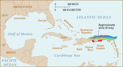
The islands are located along the Puerto Rico Trench, an oceanic trench located on the boundary between the Caribbean Sea and the Atlantic Ocean. The trench is associated with a complex transition between the subduction zone to the south along the Lesser Antilles island arc and the major transform fault zone or plate boundary that extends west between Cuba and Hispaniola through the Cayman Trench to the coast of Central America.

The island of Puerto Rico lies immediately to the south of the fault zone and the trench. The trench is 800 kilometres (497 mi) long and has a maximum depth of 8,000 metres (26,247 ft) at Milwaukee Deep, which is the deepest point in the Atlantic Ocean and the deepest point not in the Pacific Ocean.

Perspective view of the sea floor of the Atlantic Ocean and the Caribbean Sea. The Lesser Antilles are on the lower left side of the view and Florida is on the upper right. The purple sea floor at the center of the view is the Puerto Rico trench, the deepest part of the Atlantic Ocean and the Caribbean Sea. Image Vsmith
Location map Puerto Rico trench - USGS

Scientific studies by the National Oceanic and Atmospheric Administration (NOAA) have found that an earthquake occurring along this fault zone could generate a significant tsunami.   NOAA stated: “A large fault system, which is similar to the San Andreas Fault in California, was discovered in very deep water near the trench. Much of the horizontal sliding between the North American and Caribbean plates occurs along this fault. The fault was named after Dr. Elizabeth (Betty) Bunce, a marine geophysicist pioneer who investigated this challenging environment in the 1950s.”

Since 1988, the Puerto Rican Seismic Society has been using the Puerto Rican media to inform people about a future earthquake.

Puerto Rico Trench Earthquake/Tsunami History

Tectonic and seismic map of Puerto Rico Trench area. Arrows show direction of plate movements. USGS.

On 11 October 1918, the western coast of the island was hit by a major earthquake (7.5 magnitude), which produced a tsunami. In 1953, Santo Domingo, Dominican Republic, was affected by the Santo Domingo earthquake. The 1918 earthquake was caused by an old left-lateral strike-slip fault near the Mona passage. The actual subduction zone (Puerto Rico Trench) hasn’t ruptured in over 200 years.

Puerto Rico in particular has always been an area of concern to earthquake experts because, apart from the 1918 episode, there are frequent cases of tremors in and around the island. A 1981 tremor was felt across the island, while another in 1985 was felt in the towns of Cayey and Salinas.

Other significant earthquakes in the region:

1787 – Anegada Trough: 8.1m

1867 – Mona Canyon: 7.5m

1946 – Mona Canyon: 7.5m

1946 – Dominican Republic: 8.1

1953 – Dominican Republic: 6.9

During 2010 the Puerto Rico Seismic Network (PRSN) located 1681 tremors, 1058 less than previous year, 2010. 68 earthquakes were reported as felt. The magnitudes calculated by the PRSN during 2010 ranged from 0.5 to 5.70. Depths were distributed between 0.3 to 200.7 km, while for felt earthquakes depths ranged from 0.2 to 159.1 km.

http://stevequayle.com/start.html