

Volcano showers sand and ash over Guatemala: institute
Staff Writers
Winds were carrying the ash in a northeasterly direction from the volcano, 2,500 meters (7,500 feet) above sea level in the province of Quetzaltenango , 206 kilometers (123 miles) west of the capital, it said.

Santiaguito volcano. (See photo at right)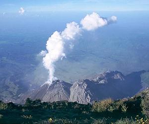
The ash plume spread across six provinces, raising fears of damage to crops, the institute said, while classes were suspended at schools in three provinces.
The national disaster reduction coordination agency CONRED increased its alert level to orange, one level below the maximum red, its director Alejandro Maldonado said.
The volcanic activity propelled gray ash more than 27,000 feet (8,300 meters) into the air, and Conred advised civil aviation authorities to ban flying within 15 kilometers (nine miles) of the volcano.
Santiaguito's worst eruption occurred in 1929 when 2,500 people were killed.
April 28, 2010