FourWinds10.com - Delivering Truth Around the World
Custom Search

Thanks to Dr. Strange

Smaller Font Larger Font RSS 2.0

 
It is interesting to note that the United States Geological Survey (USGS) has a website that lists:
"Latest Earthquakes Magnitude 2.5 or Greater in the United States and Adjacent Areas and Magnitude 4.0 or Greater in the Rest of the World - Last 7 days" at: http://earthquake.usgs.gov/eqcenter/recenteqsww/Quakes/quakes_all.php
 
The data includes:

Magnitude (SWS), UTC Day-Time, Latitude, Longitude, Depth (km), and a Region Name.

 
So, I have been saving all of these data since September 2006 in an Excel spreadsheet, with each EQ event in each row, and all of the data in separate columns.
 
Using Excel macros, I can pull out the data for any given region, and plot the EQ Mag. or any other data vs. time. The results are very interesting...
 
For example:
 
Our Moon does not go around the Earth in a perfect circle; the orbit wobbles.

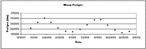
So, there are times that the center of the Moon comes the closest to the center of the Earth (Perigee), and times when the center of the Moon is furthest from the center of the Earth (Apogee).

The exact days of Moon Perigee can be found in Naval handbooks at the library.

 
Moon Perigee occurs about once a month, and there is a time about every six and a half months, when the Moon comes the closest to the Earth (Max. Perigee).

The next Max. Perigee will be on June 3, with an almost equal max. on May 6.

The data for Moon Perigee during 2008 is shown below.

 
I have noted that all of the major EQs in Northern California occur within a few days near Moon Perigee.

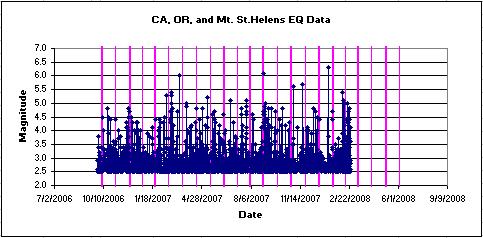
The data, shown below, supports that.  The longer vertical lines are the Moon Perigee dates.

 
Now, what is really interesting to me is what has been happening in Baja California, and that is not being reported in the US News...
 
The recent EQ activity in Baja California, Mexico, is shown below, and is occurring almost always in the same location, centered near 32.4 Latitude and -115.3 Longitude.  Where?...

Using this Mapquest website:

 
http://www.mapquest.com/maps/main.adp?formtype=latlong&cat=32.456%3Cbr%3E-115.317&address=&city=&state=&zipcode=
 
and using the lower button, we see that this location is about 2/3's the way NNW from the Sea of Cortez to the US Border, near Mexicali.
 
Look at the data plots for these Baja EQs that began about 2 weeks ago:

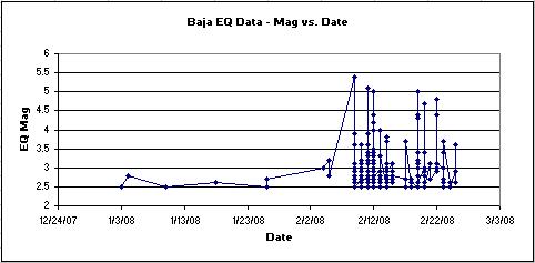
There have 74 EQs of 3.0 and greater, 13 EQs of 4.0 and greater and 4 EQs of 5.0 and greater!

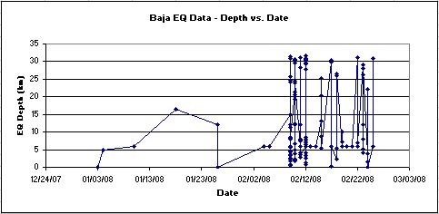
Also, look at Depths of the EQs vs. time: 37 of these have been over 20 km (12 miles) deep!

Something big is happening!!!...

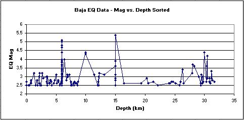
I have also plotted the magnitude of the EQs vs. depth, which shows that there are a lot of EQs happening at great depths, and two (4.2 and 4.4) near 30 km

(18 miles) deep!

 
OK, so what?...
 
Well, did you hear about the 6.0 EQ in Wells, Nevada, on February 21st?  Last Thursday!
 
http://www.kutv.com/content/news/local/story.aspx?content_id=b0b77f3f-c341-4852-badf-990e421e7960
 
The USGS data says that this was at 41.077 Lat. and -114.752 Log., which is just East of the town of Wells, NV, at 9 km deep, and is just about due North on the Baja EQs!

On the same EQ fault line? I don't know...  Who really knows?...

 
Add to that recent newspapers articles about fears that there may be an EQ coming for Idaho! - and I note that Twin Falls is just North of Well, NV...
 
So, these could all be related...
 
The next Moon Perigee (and the 4th to Max.) is on March 10: 2 weeks from today!!!
 
As Valentine Michael Smith said in Robert Heinlein's classic: "Waiting is."
 
And, as Swami Beyondananda has said: "While driving your karma, please curb your dogma.   We all have our faults. It is best not to dwell on them..."
 
From:  remelin@cebridge.net