
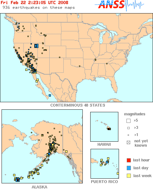
North American Quakes in Last 72 Hours
USGS headers for the lines of text below read across like this:
Size Date UTC
Time
LAT. -LONG. Depth Region
Mag. 2.3 Feb. 10 20:40:53 37.861 -122.239 9.8 (2 mi) ESE
of Berkeley
Times are posted in Coordinated Universal Time (UTC). Convert to local time.
--------------------------------------------------------------------------------
February 21, 2008 - evening update
Holly Deyo
Earthquake activity remains elevated at 936 events. Most notable is today's 6.0 jolt in Elko. Though this is in 'earthquake territory' nothing of this size has hit here for more than 30 years. Reports are coming in of major building damage and cracked walls.
And now Alaska wants back in the game with some rather sizeable jolts today.
The Baja area is still busy and with Tuesday's 5.0 shaker, a flurry of smaller aftershocks have hit. There are way too many EQs to post as is normally done below, but you can see what's going on with these maps.
Many of these EQs have occurred on top of each other on the maps below so you can't see them as individual events. Where this is the case, individual state maps are included.
When looking at the legend for these USGS earthquake maps, keep in mind their time frames of "last hour, last day, last week." This can be confusing because any shaker that occurred even 25 hours ago, falls into the "last week" category since their is no daily breakdown.

CASCADE RANGE — GO TO CURRENT MOUNT ST. HELENS UPDATE
Mag. 1.6 Feb. 21 17:01:44 46.916 -121.968 7.0 18 km ( 11 mi) NNE of Ashford, WA
Mag. 2.0 Feb. 21 09:22:39 48.608 -121.979 0.2 9 km ( 6 mi) N of Hamilton, WA
Mag. 1.4 Feb. 20 16:50:17 48.769 -123.125 51.6 27 km ( 17 mi) NNW of Friday Harbor, WA
Mag. 1.8 Feb. 20 01:12:44 44.238 -118.214 0.0 23 km ( 15 mi) S of Unity, OR
Mag. 1.5 Feb. 20 00:38:02 46.377 -122.374 22.5 19 km ( 12 mi) SSE of Mossyrock, WA
Mag. 2.1 Feb. 20 00:23:20 46.888 -119.922 2.2 8 km ( 5 mi) SE of Vantage, WA
Mag. 1.4 Feb. 19 21:52:23 47.606 -122.017 9.7 2 km ( 1 mi) E of Sammamish, WA
CALIFORNIA 2.0 and greater
Mag. 2.3 Feb. 22 02:20:14 40.291 -121.540 9.6 8 km ( 5 mi) SSE of Mineral
Mag. 2.8 Feb. 21 21:19:46 36.590 -118.034 4.7 3 km ( 2 mi) E of Lone Pine
Mag. 2.7 Feb. 21 15:29:51 38.833 -122.757 1.1 3 km ( 2 mi) W of Cobb
Mag. 2.4 Feb. 21 02:47:02 36.552 -121.109 8.6 4 km ( 2 mi) NE of Pinnacles
Mag. 2.2 Feb. 20 20:31:30 37.914 -122.290 5.3 1 km ( 1 mi) ESE of El Cerrito
Mag. 2.3 Feb. 20 14:34:58 36.589 -118.038 11.5 3 km ( 2 mi) E of Lone Pine
Mag. 2.1 Feb. 20 04:07:04 35.962 -118.314 5.6 26 km ( 16 mi) NNE of Kernville
Mag. 2.4 Feb. 19 16:05:12 35.951 -117.730 1.4 22 km ( 14 mi) ESE of Coso Junction
Mag. 2.4 Feb. 19 13:02:28 39.856 -123.506 6.8 20 km ( 13 mi) N of Laytonville
Mag. 2.5 Feb. 19 10:39:08 33.538 -115.889 2.8 5 km ( 3 mi) ENE of North Shore
Mag. 3.2 Feb. 19 09:15:09 32.141 -115.883 0.1 60 km ( 37 mi) SSE of Jacumba Hot Springs
Mag. 2.0 Feb. 19 05:48:11 34.283 -117.046 7.4 10 km ( 6 mi) NE of Running Springs
Mag. 2.0 Feb. 19 03:36:47 36.552 -121.110 8.8 4 km ( 2 mi) NE of Pinnacles
Mag. 2.2 Feb. 19 00:33:08 36.440 -121.008 0.7 16 km ( 10 mi) SE of Pinnacles
Mag. 3.2 Feb. 19 00:16:36 33.022 -118.923 6.0 30 km ( 18 mi) W of San Clemente Is. (NW tip)
Mag. 2.1 Feb. 18 22:40:52 38.812 -122.823 2.6 2 km ( 1 mi) NW of The Geysers
Mag. 2.3 Feb. 18 19:31:06 32.170 -115.845 6.0 59 km ( 37 mi) SSE of Jacumba Hot Springs
Mag. 2.1 Feb. 18 16:40:27 32.982 -115.780 11.9 16 km ( 10 mi) WSW of Westmorland
Mag. 3.7 Feb. 18 15:15:31 36.587 -118.026 9.3 4 km ( 2 mi) E of Lone Pine
Mag. 2.0 Feb. 18 05:59:32 38.792 -122.758 2.2 4 km ( 3 mi) E of The Geysers
Mag. 2.5 Feb. 18 00:23:43 40.521 -124.160 14.3 5 km ( 3 mi) WNW of Rio Dell
NEVADA
Mag. 1.5 Feb. 22 01:22:32 38.561 -118.167 4.0 6 km ( 4 mi) N of Luning
Mag. 1.0 Feb. 22 00:38:14 37.285 -116.424 4.0 51 km ( 32 mi) NE of Beatty
Mag. 4.6 Feb. 21 23:57:52 41.053 -114.923 10.0 7 km ( 5 mi) SSE of Wells
Mag. 2.2 Feb. 21 23:21:46 40.583 -117.111 0.0 16 km ( 10 mi) WSW of Battle Mountain
Mag. 2.8 Feb. 21 23:02:53 40.841 -114.796 4.0 13 km ( 8 mi) WNW of Spruce
Mag. 3.2 Feb. 21 22:47:29 41.100 -115.000 10.0 3 km ( 2 mi) WSW of Wells
Mag. 1.2 Feb. 21 20:43:09 37.393 -117.104 12.0 17 km ( 11 mi) NE of Tokop
Mag. 1.8 Feb. 21 19:15:02 38.366 -116.246 0.0 22 km ( 14 mi) NNE of Warm Springs
Mag. 3.1 Feb. 21 17:01:46 41.038 -115.028 5.0 9 km ( 6 mi) SSW of Wells
Mag. 3.9 Feb. 21 16:20:03 41.058 -114.822 5.0 14 km ( 8 mi) ESE of Wells
Mag. 3.3 Feb. 21 16:14:17 41.168 -114.803 10.0 15 km ( 10 mi) ENE of Wells
Mag. 3.1 Feb. 21 16:05:55 41.151 -114.992 10.0 5 km ( 3 mi) NNW of Wells
Mag. 3.0 Feb. 21 15:50:28 41.145 -114.841 10.0 11 km ( 7 mi) ENE of Wells
Mag. 2.7 Feb. 21 15:48:22 41.220 -114.966 10.0 12 km ( 8 mi) N of Wells
Mag. 2.7 Feb. 21 15:43:15 41.030 -114.854 10.0 13 km ( 8 mi) SE of Wells
Mag. 2.9 Feb. 21 15:40:10 41.682 -116.791 10.0 62 km ( 38 mi) WSW of Owyhee
Mag. 3.7 Feb. 21 15:34:26 41.026 -114.873 10.0 12 km ( 8 mi) SE of Wells
Mag. 2.5 Feb. 21 15:13:43 39.103 -118.038 16.0 28 km ( 17 mi) NNW of Gabbs
Mag. 2.5 Feb. 21 14:47:07 39.844 -117.880 16.0 24 km ( 15 mi) NE of Dixie Valley
Mag. 6.0 Feb. 21 14:16:05 41.076 -114.771 10.0 17 km ( 11 mi) ESE of Wells
Mag. 2.0 Feb. 20 21:19:23 36.019 -115.261 0.0 6 km ( 4 mi) WSW of Enterprise
Mag. 1.3 Feb. 20 20:31:05 37.735 -117.227 16.0 4 km ( 3 mi) ENE of West Spring
Mag. 1.7 Feb. 20 20:12:06 38.398 -117.321 0.0 37 km ( 23 mi) NNW of Tonopah
Mag. 1.1 Feb. 20 14:03:24 37.456 -115.864 4.0 30 km ( 19 mi) SW of Tempiute
Mag. 1.1 Feb. 20 15:22:50 37.393 -117.104 12.0 17 km ( 11 mi) NE of Tokop
Mag. 1.2 Feb. 20 11:26:28 37.373 -117.105 8.0 16 km ( 10 mi) ENE of Tokop
Mag. 1.3 Feb. 20 09:59:12 37.374 -117.130 12.0 14 km ( 9 mi) NE of Tokop
Mag. 1.2 Feb. 20 07:28:11 37.373 -117.105 0.0 16 km ( 10 mi) ENE of Tokop
Mag. 1.9 Feb. 19 23:42:09 38.775 -116.828 0.0 55 km ( 34 mi) SE of Washington
Mag. 1.2 Feb. 19 23:28:12 36.574 -115.015 0.0 20 km ( 13 mi) NW of Dry Lake
Mag. 1.0 Feb. 19 23:01:56 36.851 -115.681 0.0 31 km ( 19 mi) N of Indian Springs
Mag. 1.8 Feb. 19 20:10:16 38.657 -117.138 0.0 56 km ( 35 mi) S of Washington
Mag. 1.2 Feb. 19 01:46:12 38.541 -117.910 16.0 24 km ( 15 mi) E of Luning
Mag. 1.6 Feb. 18 04:14:09 38.180 -118.243 0.0 16 km ( 10 mi) SW of Tonopah Junction
Mag. 2.5 Feb. 18 06:09:59 38.396 -118.192 12.1 12 km ( 8 mi) S of Luning
Mag. 1.0 Feb. 18 00:27:37 38.847 -118.929 11.7 16 km ( 10 mi) SW of Schurz
YELLOWSTONE region
Mag. 1.8 Feb. 21 00:42:43 47.721 -114.846 0.0 16 km ( 10 mi) WNW of Lonepine, MT
Mag. 2.3 Feb. 18 19:19:25 47.924 -114.800 0.0 20 km ( 12 mi) WNW of Niarada, MT
Mag. 1.0 Feb. 18 11:34:18 42.044 -111.910 6.2 5 km ( 3 mi) E of Weston, ID
UTAH
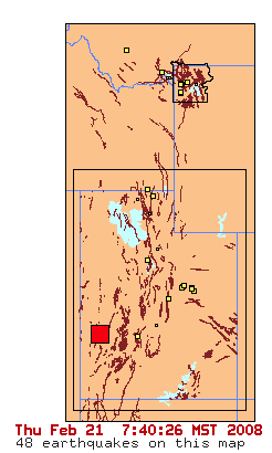
Mag. 4.0 Feb. 21 14:35:34 38.577 -113.410 7.3 40 km ( 25 mi) WNW of Milford - later deleted by USGS
Mag. 1.0 Feb. 20 08:49:35 38.544 -112.225 1.7 9 km ( 6 mi) S of Joseph
Mag. 1.3 Feb. 20 02:03:30 39.679 -110.487 4.2 16 km ( 10 mi) NNW of Sunnyside
Mag. 1.3 Feb. 19 16:50:47 39.735 -110.742 1.2 11 km ( 7 mi) ENE of Helper
Mag. 1.4 Feb. 19 16:42:55 39.735 -110.741 1.2 11 km ( 7 mi) ENE of Helper
Mag. 1.6 Feb. 19 10:07:47 39.704 -110.806 0.1 5 km ( 3 mi) ENE of Helper
Mag. 1.1 Feb. 19 05:54:25 39.738 -110.747 1.2 11 km ( 7 mi) ENE of Helper
Mag. 1.2 Feb. 18 11:49:32 39.673 -110.493 2.0 16 km ( 10 mi) NNW of Sunnyside
Mag. 1.3 Feb. 18 10:18:50 40.355 -111.891 0.5 3 km ( 2 mi) NNE of Saratoga Springs
Mag. 1.1 Feb. 18 03:21:02 39.675 -110.489 2.0 16 km ( 10 mi) NNW of Sunnyside
ARIZONA
Mag. 1.1 Feb. 21 20:05:25 33.066 -114.935 0.0 41 km ( 25 mi) SW of Cibola
Mag. 2.0 Feb. 20 01:38:23 35.035 -114.536 0.0 8 km ( 5 mi) NNE of Mesquite Creek
Mag. 1.6 Feb. 19 00:21:09 33.070 -114.974 0.0 43 km ( 26 mi) SW of Cibola
NEW MADRID
Mag. 1.7 Feb. 20 18:06:20 36.490 -89.530 7.9 8 km ( 5 mi) ESE of Marston, MO
Mag. 1.3 Feb. 20 11:56:36 36.490 -89.560 8.7 5 km ( 3 mi) SE of Marston, MO
Mag. 1.1 Feb. 20 02:40:34 35.060 -84.640 15.6 13 km ( 8 mi) S of Benton, TN
ALASKA 3.0 and greater For a COMPLETE of Alaska Events, go here:

Mag. 3.8 Feb. 22 00:51:37 51.620 -177.316 60.4 55 km ( 34 mi) WSW of Adak
Mag. 3.7 Feb. 22 00:46:07 51.651 -177.344 63.3 55 km ( 34 mi) WSW of Adak
Mag. 4.8 Feb. 22 00:15:59 51.502 -177.308 52.7 62 km ( 39 mi) SW of Adak
Mag. 4.6 Feb. 22 00:05:11 50.998 -177.217 25.7 106 km ( 66 mi) SSW of Adak
Mag. 3.1 Feb. 22 00:01:51 51.698 -177.384 64.7 55 km ( 34 mi) WSW of Adak
Mag. 5.5 Feb. 21 23:52:15 51.261 -177.336 70.9 84 km ( 52 mi) SW of Adak
Mag. 4.8 Feb. 21 23:51:53 51.079 -177.337 34.3 102 km ( 63 mi) SSW of Adak
Mag. 3.5 Feb. 21 05:36:51 60.127 -152.213 97.6 34 km ( 21 mi) NW of Happy Valley
Mag. 4.1 Feb. 21 01:44:01 51.840 -174.352 42.2 41 km ( 25 mi) SSW of Atka
Mag. 3.7 Feb. 20 15:51:27 63.216 -149.352 90.8 30 km ( 18 mi) SW of Cantwell
Mag. 3.0 Feb. 20 12:37:40 53.906 -164.211 33.9 107 km ( 67 mi) ESE of Akutan
Mag. 3.1 Feb. 20 05:09:28 53.261 -167.619 56.0 90 km ( 56 mi) ENE of Nikolski
Mag. 3.1 Feb. 19 18:37:15 61.463 -140.437 0.0 106 km ( 66 mi) SE of Chisana
Mag. 3.5 Feb. 19 15:01:12 56.142 -157.994 63.4 31 km ( 19 mi) SE of Chignik
Mag. 3.3 Feb. 19 05:15:08 52.557 -180.049 100.0 244 km (151 mi) WNW of Adak
HAWAII 2.0 and greater
Mag. 2.1 Feb. 20 18:45:54 19.309 -155.216 7.4 16 km ( 10 mi) S of Volcano
Mag. 3.9 Feb. 20 04:14:47 19.323 -155.217 10.4 14 km ( 9 mi) S of Volcano
Mag. 2.1 Feb. 19 22:32:02 19.407 -155.476 7.0 23 km ( 14 mi) N of Pahala
Mag. 2.2 Feb. 18 16:18:32 19.262 -155.496 2.4 7 km ( 4 mi) NNW of Pahala
CARIBBEAN
Mag. 3.2 Feb. 21 17:52:20 18.590 -65.310 77.9 31 km ( 20 mi) N of Culebra, PR
Mag. 2.8 Feb. 19 22:12:45 17.681 -66.031 6.9 32 km ( 20 mi) S of Arroyo, PR
Mag. 3.4 Feb. 19 09:55:27 18.781 -65.078 69.1 50 km ( 31 mi) NNW of Charlotte Amalie, US Virgin Islands
Mag. 3.6 Feb. 19 08:34:12 19.864 -64.908 77.1 140 km ( 87 mi) NNW of Settlement, British Virgin Islands
Mag. 3.3 Feb. 18 06:24:33 18.992 -65.040 24.6 72 km ( 44 mi) NNW of Little Harbour, British Virgin Islands
CANADA
BAJA / MEXICO
Mag. 2.4 Feb. 21 17:22:39 32.407 -115.291 6.0 21 km ( 13 mi) NW of Guadalupe Victoria
Mag. 2.7 Feb. 21 22:04:23 31.924 -116.142 6.0 45 km ( 28 mi) E of Ensenada
Mag. 2.2 Feb. 21 21:27:39 32.426 -115.312 6.0 24 km ( 15 mi) NW of Guadalupe Victoria
Mag. 1.7 Feb. 21 15:55:41 32.467 -115.314 6.0 25 km ( 16 mi) SE of Mexicali
Mag. 2.2 Feb. 21 07:17:50 32.363 -115.372 12.1 26 km ( 16 mi) WNW of Guadalupe Victoria
Mag. 3.1 Feb. 21 04:32:54 32.417 -115.320 30.2 24 km ( 15 mi) NW of Guadalupe Victoria
Mag. 2.4 Feb. 21 00:05:00 32.421 -115.271 8.3 21 km ( 13 mi) NW of Guadalupe Victoria
Mag. 2.4 Feb. 20 23:17:25 32.394 -115.282 23.1 20 km ( 12 mi) NW of Guadalupe Victoria
Mag. 2.3 Feb. 20 19:28:22 32.391 -115.318 12.2 23 km ( 14 mi) WNW of Guadalupe Victoria
Mag. 2.4 Feb. 20 15:58:29 32.410 -115.277 8.2 21 km ( 13 mi) NW of Guadalupe Victoria
Mag. 2.8 Feb. 20 14:57:00 32.406 -115.330 6.0 24 km ( 15 mi) WNW of Guadalupe Victoria
Mag. 2.3 Feb. 20 12:09:37 32.369 -115.333 7.2 23 km ( 14 mi) WNW of Guadalupe Victoria
Mag. 2.9 Feb. 20 11:49:23 32.407 -115.295 6.0 22 km ( 13 mi) NW of Guadalupe Victoria
Mag. 1.9 Feb. 20 09:40:38 32.425 -115.317 6.0 25 km ( 15 mi) NW of Guadalupe Victoria
Mag. 2.0 Feb. 20 09:33:02 32.400 -115.335 6.0 24 km ( 15 mi) WNW of Guadalupe Victoria
Mag. 1.6 Feb. 20 08:52:44 32.445 -115.344 6.0 26 km ( 16 mi) SSE of Mexicali
Mag. 1.7 Feb. 20 08:45:10 32.432 -115.312 6.0 25 km ( 15 mi) NW of Guadalupe Victoria
Mag. 2.1 Feb. 20 08:24:31 32.433 -115.304 6.0 24 km ( 15 mi) NW of Guadalupe Victoria
Mag. 1.8 Feb. 20 08:18:14 32.470 -115.322 6.0 24 km ( 15 mi) SE of Mexicali
Mag. 1.7 Feb. 20 08:09:48 32.367 -115.341 6.0 23 km ( 15 mi) WNW of Guadalupe Victoria
Mag. 2.3 Feb. 20 07:05:40 32.428 -115.318 6.0 25 km ( 15 mi) NW of Guadalupe Victoria
Mag. 2.0 Feb. 20 06:57:38 32.432 -115.303 6.0 24 km ( 15 mi) NW of Guadalupe Victoria
Mag. 2.4 Feb. 20 06:35:43 32.424 -115.331 6.0 26 km ( 16 mi) NW of Guadalupe Victoria
Mag. 3.0 Feb. 20 06:13:33 32.427 -115.294 6.0 23 km ( 14 mi) NW of Guadalupe Victoria
Mag. 1.7 Feb. 20 06:00:44 32.428 -115.314 6.0 25 km ( 15 mi) NW of Guadalupe Victoria
Mag. 1.9 Feb. 20 05:43:11 32.391 -115.279 6.0 19 km ( 12 mi) NW of Guadalupe Victoria
Mag. 2.4 Feb. 20 05:32:41 32.437 -115.289 6.0 23 km ( 15 mi) NW of Guadalupe Victoria
Mag. 2.3 Feb. 20 05:21:20 32.419 -115.315 6.0 24 km ( 15 mi) NW of Guadalupe Victoria
Mag. 2.3 Feb. 20 04:37:19 32.452 -115.304 6.0 26 km ( 16 mi) NW of Guadalupe Victoria
Mag. 2.4 Feb. 20 04:35:05 32.407 -115.309 6.0 23 km ( 14 mi) NW of Guadalupe Victoria
Mag. 2.1 Feb. 20 04:22:45 32.413 -115.324 6.0 24 km ( 15 mi) NW of Guadalupe Victoria
Mag. 2.0 Feb. 20 04:16:10 32.409 -115.311 6.0 23 km ( 14 mi) NW of Guadalupe Victoria
Mag. 1.8 Feb. 20 04:00:23 32.333 -115.302 6.0 19 km ( 12 mi) WNW of Guadalupe Victoria
Mag. 2.1 Feb. 20 03:59:22 32.401 -115.325 6.0 24 km ( 15 mi) WNW of Guadalupe Victoria
Mag. 1.7 Feb. 20 03:58:05 32.426 -115.309 6.0 24 km ( 15 mi) NW of Guadalupe Victoria
Mag. 1.6 Feb. 20 03:55:43 32.423 -115.304 6.0 23 km ( 15 mi) NW of Guadalupe Victoria
Mag. 1.8 Feb. 20 03:51:52 32.435 -115.304 6.0 24 km ( 15 mi) NW of Guadalupe Victoria
Mag. 1.6 Feb. 20 03:48:39 32.422 -115.311 6.0 24 km ( 15 mi) NW of Guadalupe Victoria
Mag. 2.2 Feb. 20 03:46:23 32.415 -115.323 5.9 24 km ( 15 mi) NW of Guadalupe Victoria
Mag. 2.4 Feb. 20 03:37:56 32.435 -115.299 6.0 24 km ( 15 mi) NW of Guadalupe Victoria
Mag. 2.4 Feb. 20 03:09:48 32.433 -115.314 6.0 25 km ( 15 mi) NW of Guadalupe Victoria
Mag. 2.2 Feb. 20 02:45:55 32.438 -115.302 6.0 24 km ( 15 mi) NW of Guadalupe Victoria
Mag. 1.8 Feb. 20 02:35:47 32.436 -115.322 6.0 26 km ( 16 mi) NW of Guadalupe Victoria
Mag. 1.9 Feb. 20 02:15:26 32.433 -115.314 6.0 25 km ( 15 mi) NW of Guadalupe Victoria
Mag. 2.6 Feb. 20 01:53:27 32.419 -115.319 6.0 24 km ( 15 mi) NW of Guadalupe Victoria
Mag. 3.4 Feb. 20 01:37:38 32.427 -115.316 6.0 25 km ( 15 mi) NW of Guadalupe Victoria
Mag. 4.7 Feb. 20 01:28:55 32.426 -115.306 6.0 24 km ( 15 mi) NW of Guadalupe Victoria
Mag. 2.4 Feb. 20 01:22:32 32.404 -115.288 6.0 21 km ( 13 mi) NW of Guadalupe Victoria
Mag. 2.0 Feb. 20 01:10:05 32.398 -115.313 6.0 22 km ( 14 mi) WNW of Guadalupe Victoria
Mag. 2.5 Feb. 20 01:07:32 32.399 -115.280 6.0 20 km ( 12 mi) NW of Guadalupe Victoria
Mag. 2.5 Feb. 20 00:57:41 32.468 -115.322 6.0 25 km ( 15 mi) SE of Mexicali
Mag. 1.9 Feb. 20 00:53:31 32.407 -115.314 6.0 23 km ( 14 mi) NW of Guadalupe Victoria
Mag. 1.7 Feb. 20 00:46:10 32.428 -115.291 6.0 23 km ( 14 mi) NW of Guadalupe Victoria
Mag. 3.0 Feb. 20 00:30:03 32.442 -115.302 6.0 25 km ( 15 mi) NW of Guadalupe Victoria
Mag. 1.9 Feb. 20 00:25:24 32.403 -115.324 6.0 24 km ( 15 mi) WNW of Guadalupe Victoria
Mag. 1.9 Feb. 20 00:22:36 32.418 -115.296 6.0 22 km ( 14 mi) NW of Guadalupe Victoria
Mag. 2.1 Feb. 20 00:20:03 32.389 -115.288 6.0 20 km ( 12 mi) NW of Guadalupe Victoria
Mag. 3.0 Feb. 20 00:15:51 32.418 -115.311 6.0 24 km ( 15 mi) NW of Guadalupe Victoria
Mag. 2.1 Feb. 20 00:14:31 32.422 -115.302 6.0 23 km ( 14 mi) NW of Guadalupe Victoria
Mag. 1.9 Feb. 20 00:13:16 32.424 -115.286 6.0 22 km ( 14 mi) NW of Guadalupe Victoria
Mag. 2.4 Feb. 20 00:09:01 32.397 -115.281 6.0 20 km ( 12 mi) NW of Guadalupe Victoria
Mag. 2.4 Feb. 20 00:07:19 32.433 -115.294 6.0 23 km ( 15 mi) NW of Guadalupe Victoria
Mag. 2.1 Feb. 20 00:06:20 32.362 -115.276 6.0 18 km ( 11 mi) WNW of Guadalupe Victoria
Mag. 2.6 Feb. 19 23:54:28 32.414 -115.291 6.0 22 km ( 14 mi) NW of Guadalupe Victoria
Mag. 2.6 Feb. 19 23:53:18 32.404 -115.295 6.0 21 km ( 13 mi) NW of Guadalupe Victoria
Mag. 3.0 Feb. 19 23:50:44 32.401 -115.306 6.0 22 km ( 14 mi) NW of Guadalupe Victoria
Mag. 1.9 Feb. 19 23:48:50 32.425 -115.293 6.0 23 km ( 14 mi) NW of Guadalupe Victoria
Mag. 2.1 Feb. 19 23:40:12 32.468 -115.294 6.0 26 km ( 16 mi) SE of Mexicali
Mag. 1.9 Feb. 19 23:39:16 32.465 -115.327 6.0 25 km ( 15 mi) SSE of Mexicali
Mag. 1.7 Feb. 19 23:34:55 32.489 -115.311 6.0 23 km ( 15 mi) SE of Mexicali
Mag. 2.2 Feb. 19 23:33:22 32.419 -115.308 6.0 23 km ( 15 mi) NW of Guadalupe Victoria
Mag. 2.4 Feb. 19 23:31:51 32.432 -115.341 6.0 27 km ( 17 mi) NW of Guadalupe Victoria
Mag. 2.3 Feb. 19 23:27:23 32.429 -115.291 6.0 23 km ( 14 mi) NW of Guadalupe Victoria
Mag. 2.8 Feb. 19 23:22:11 32.412 -115.293 6.0 22 km ( 14 mi) NW of Guadalupe Victoria
Mag. 2.2 Feb. 19 23:19:08 32.403 -115.277 6.0 20 km ( 12 mi) NW of Guadalupe Victoria
Mag. 3.1 Feb. 19 23:00:35 32.430 -115.291 6.0 23 km ( 14 mi) NW of Guadalupe Victoria
Mag. 1.5 Feb. 19 22:58:35 32.391 -115.237 6.0 16 km ( 10 mi) NW of Guadalupe Victoria
Mag. 2.3 Feb. 19 22:57:35 32.418 -115.305 6.0 23 km ( 14 mi) NW of Guadalupe Victoria
Mag. 2.4 Feb. 19 22:54:26 32.531 -115.355 6.0 17 km ( 11 mi) SE of Mexicali
Mag. 3.2 Feb. 19 22:51:08 32.429 -115.318 6.0 25 km ( 15 mi) NW of Guadalupe Victoria
Mag. 3.4 Feb. 19 22:47:32 32.395 -115.292 6.0 21 km ( 13 mi) NW of Guadalupe Victoria
Mag. 5.0 Feb. 19 22:41:29 32.432 -115.313 6.0 25 km ( 15 mi) NW of Guadalupe Victoria
Mag. 4.4 Feb. 19 20:24:25 29.581 -114.222 10.0 158 km ( 98 mi) NNW of Santa Isabel
Mag. 2.0 Feb. 19 20:03:28 32.568 -116.780 0.0 14 km ( 9 mi) W of Tecate
Mag. 4.3 Feb. 19 19:00:30 29.112 -114.625 10.0 132 km ( 82 mi) NNW of Guerrero Negro
Mag. 2.6 Feb. 19 16:08:43 32.403 -115.291 6.0 21 km ( 13 mi) NW of Guadalupe Victoria
Mag. 2.3 Feb. 19 11:33:57 32.369 -115.326 6.0 22 km ( 14 mi) WNW of Guadalupe Victoria
Mag. 1.7 Feb. 19 10:42:21 32.427 -115.314 6.1 25 km ( 15 mi) NW of Guadalupe Victoria
Mag. 2.2 Feb. 19 09:05:18 32.390 -115.317 6.0 22 km ( 14 mi) WNW of Guadalupe Victoria
Mag. 2.5 Feb. 19 06:07:56 32.416 -115.328 6.0 25 km ( 15 mi) NW of Guadalupe Victoria
Mag. 1.7 Feb. 19 00:25:39 32.462 -115.316 6.0 25 km ( 16 mi) SE of Mexicali
Mag. 1.9 Feb. 19 00:08:38 32.438 -115.308 6.0 25 km ( 15 mi) NW of Guadalupe Victoria
Mag. 2.1 Feb. 18 21:29:48 32.433 -115.302 6.0 24 km ( 15 mi) NW of Guadalupe Victoria
Mag. 2.2 Feb. 18 12:14:26 32.408 -115.334 3.2 25 km ( 15 mi) WNW of Guadalupe Victoria
Mag. 2.6 Feb. 18 11:57:08 32.435 -115.316 6.0 25 km ( 16 mi) NW of Guadalupe Victoria
Mag. 2.7 Feb. 18 11:43:39 32.426 -115.285 6.0 22 km ( 14 mi) NW of Guadalupe Victoria
Mag. 2.4 Feb. 18 11:43:19 32.439 -115.300 6.0 24 km ( 15 mi) NW of Guadalupe Victoria
Mag. 1.9 Feb. 18 11:36:51 32.399 -115.326 6.0 24 km ( 15 mi) WNW of Guadalupe Victoria
Mag. 2.7 Feb. 18 11:34:19 32.426 -115.306 6.0 24 km ( 15 mi) NW of Guadalupe Victoria
Mag. 2.5 Feb. 18 11:33:36 32.425 -115.324 6.0 25 km ( 16 mi) NW of Guadalupe Victoria
Mag. 1.9 Feb. 18 11:29:00 32.427 -115.334 6.0 26 km ( 16 mi) NW of Guadalupe Victoria
Mag. 2.2 Feb. 18 11:10:39 32.400 -115.328 6.0 24 km ( 15 mi) WNW of Guadalupe Victoria
Mag. 2.2 Feb. 18 04:03:38 32.425 -115.309 6.0 24 km ( 15 mi) NW of Guadalupe Victoria
Mag. 1.8 Feb. 18 03:24:48 32.359 -115.355 6.0 24 km ( 15 mi) WNW of Guadalupe Victoria
Mag. 2.1 Feb. 18 02:48:39 32.344 -115.279 6.0 17 km ( 11 mi) WNW of Guadalupe Victoria
www.standeyo.com/NEWS/08_Earth_Changes/080221.EQ.72.hrs.html