

Custom Search
Before and after: satellite images of destruction in Gaza
Truther
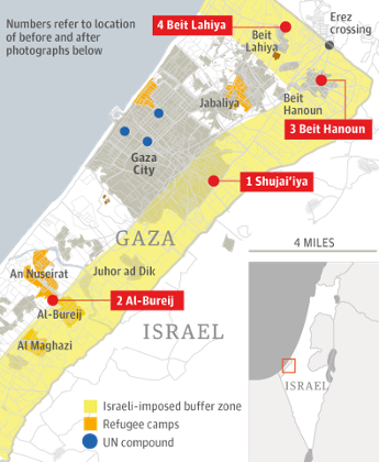
FW: Augu 11, 2014mages released by the United Nations Institute of Training and Research show the extent of the damage done by Israel’s military campaign to parts of the Gaza Strip
.jpeg)
.jpeg)

The United Nations Institute of Training and Research has released before and after images of parts of the Gaza Strip, highlighting the extent of the destruction.
An image of the area of Shujai’iya on 6 July, before the start of Israeli air strikes.
The same area 19 days later, during the strikes, with blocks of buildings razed to the ground.
A satellite photograph of al-Bureij, a Palestinian refugee camp, on July 6th.
CONTINUE READING.........
http://www.pakalertpress.com/2014/08/06/before-and-after-satellite-images-of-destruction-in-gaza/