

TEXAS DELUGE: Was it a geoengineered weather event to enforce compliance with Agenda 21?
Michael Thomas - State of the Nation
Flood of the Millennium Hits Austin, Houston, Dallas, San Marcos and other Texas cities
Major Metro Areas Paralyzed In Texas Just Before
JADE HELM 15 Begins — A Coincidence?
Michael Thomas
State of the Nation
The timing of the extraordinary May 2015 rain events in Texas, occurring just prior to the July 15th commencement of the unparalleled military exercise JADE HELM 15, cannot be coincidental. As the 1000-year flood slowly makes its way across the state, one question emerges — was it a manmade or natural weather event?
If the satellite imagery* has anything to say about this freakish statewide deluge, it is that something is very wrong with this picture, as well as with the following images.
*
*
*
*
*
*
*
*
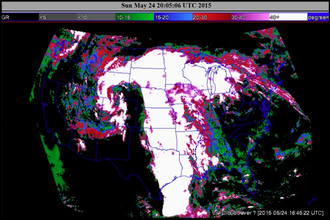
* All satellite images are from Sunday, May 24th — the day of the first deluge in Texas
The black ‘column’, which protrudes through northern Texas, Oklahoma, Kansas and Nebraska on the image above is not natural in any way, shape or form. It’s very squared off, much too angular, and straight-lined. Also, this rain event pattern is unusually vertical in its development and has been exhibiting unnatural shapes and abnormal dynamics along the way.
What is perhaps the most distinguishing feature of this apparently geoengineered weather event is that it maintained its structural integrity over several days. The longevity of any cohesive meteorological phenomenon is relatively short. In this particular case, highly unusual weather dynamics and geometries persisted over days when they would normally have morphed into new shapes and sizes, or dissolved altogether. Simply put, these kinds of weather patterns and dynamics do not exist in nature.
The following screenshot reveals the extraordinary south to north movement of the entire weather system. In other words if you click on the reference video below, the line of rainstorms is seen moving from the extreme south in the Gulf of Mexico all the way to the northern Midwest in Minnesota. The typical east to west migration of the whole storm front was not observed for a relatively prolonged period of time. The storm system just sat there training over the same areas in the blue-green areas shown below. It actually functioned like a ‘well-constructed’ conveyor belt moving massive amounts of water from the Gulf, south of Texas, right through the nation’s midsection as precipitation.
CONTINUE READING.......
http://stateofthenation2012.com/?p=15497