

UPDATE: SUPER TYPHOON NEOGURI ON PATH FOR JAPAN
Leigh Morgan
A super typhoon with the strength of a Category 4 hurricane is on a path for Japan -- and it is forecast to get even stronger as it nears the islands.
(SCROLL DOWN)
*
*
*
*
*
*
*
*
*
*
.jpg)
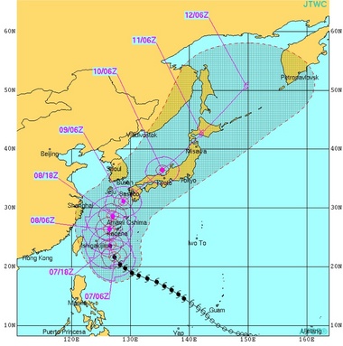 Neoguri is expected to pass close to Okinawa, Japan, but not make a direct hit. (Joint Typhoon Warning Center)
Super Typhoon Neoguri, the third typhoon of the 2014 Western Pacific season, had winds of almost 155 mph on Monday with gusts up to 190 mph, according to the Joint Typhoon Warning Center. That's close to Category 5 status on the Saffir-Simpson scale used in the U.S.
Neoguri is the strongest typhoon of 2014 in the Western Pacific so far.
Hurricanes, cyclones, and typhoons are all the same thing; scientists just call them different names depending on where they occur.
Neoguri is moving northwestward over very warm water, and is expected to strengthen more as it gets closer to Japan.
The path of the storm will take it near Okinawa, Japan.
Neoguri's rain bands could be seen approaching the islands on Monday morning on radar, and winds were already picking up.
Neoguri is not expected to hit Okinawa directly, but it will be close enough to do substantial damage to the area, which includes the U.S. Kadena Air Base.
Brig. Gen. James Hecker, the 18th Wing Commander, posted a message on the base Facebook page Sunday saying "this is not just another typhoon" and stressing personnel to take it seriously.
"I can't stress enough how dangerous this typhoon may be when it hits Okinawa. This is the most powerful typhoon forecast to hit the island in 15 years," he wrote.
Neoguri is even attracting attention from space:
So what is a super typhoon?
According to NOAA's Hurricane Research Division, a super typhoon is defined as a storm that has maximum sustained 1-minute surface winds of at least 150 mph.
That's the equivalent of a strong Category 4 or Category 5 hurricane based on the Saffir Simpson wind scale used in the U.S. by the National Hurricane Center.
The JTWC's forecast has Neoguri's winds reaching 165 mph with gusts to over 200 mph -- making it the equivalent of a Category 5 hurricane.
After its brush with Okinawa, Neoguri is expected to weaken a bit before it hits the Japanese island of Kyushu, home to the city of Nagasaki, late Wednesday or Thursday.
Tokyo is expected to escape the worst of Neoguri but will still be soaked by some rain later in the week, according to AccuWeather.com.
Tropical storms develop throughout the year in the Western Pacific, but May through October is typically the busiest period.
VIEW VIDEO
http://www.al.com/news/index.ssf/2014/07/typhoon_neoguri_on_path_for_ja.html