What does U.S. look like with a 10 feet rise of sea level asks Climate Central
Daily Kos
(SCROLL DOWN
*
*
*
*
*
*
*
*
*
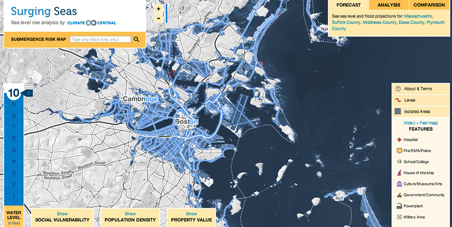
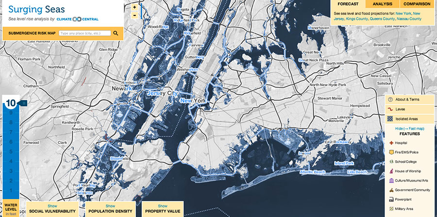
Ben Strauss of Climate Central asks What Does U.S. Look Like With 10 Feet of Sea Level Rise? Then provides some answers with excellent maps of Boston, New York City, and St. Petersberg. You'll have to follow this link to use their national map. The latest research shows the West Antarctic Ice Sheet has started melting in an unstoppable process that will increase global sea level by about 4 feet in the next 2 centuries and 10 feet by the time the process is finished.
A 10 feet rise in sea level would submerge 28,800 square miles of land in the United States, which is now home to 12.3 million people reports Ben Strauss. Including apparently much of downtown Boston, The Esplanade, Logan Airport, and major part of Cambridge, including MIT. We should have known it was a dodgy prospect to build a city on swamps which is the foundation for almost all of it except for that hill in the middle of that sea of blue in the first picture.
I'm not worried, because Gina and I are moving to Florida in July and I am sure they must have been a lot smarter down there because Florida didn't really start building up until later after we had science and city planning so I sure major expensive buildings, airports, universities, and structures wouldn't be sitting in the middle of in flood zones like we did in Boston and New York City starting back in the 1600s when people admittedly weren't all that swift. (Snark alert!) I'll look at the Florida map after I finish posting.
More than half of the area of 40 large cities (population over 50,000) is less than 10 feet above the high tide line, from Virginia Beach and Miami (the largest affected), down to Hoboken, N.J. (smallest). Twenty-seven of the cities are in Florida, where one-third of all current housing sits below the critical line — including 85 percent in Miami-Dade and Broward counties. Each of these counties is more threatened than any whole state outside of Florida – and each sits on bedrock filled with holes, rendering defense by seawalls or levees almost impossible.
By the metric of most people living on land less than 10 ft above the high tide line, New York City is most threatened in the long run, with a low-lying population count of more than 700,000. Sixteen other cities, including New Orleans, La.; Norfolk, Va.; Stockton, Calif.; Boston, Mass.; St. Petersburg, Fla.; and Jacksonville, Fla.; are on the list of places with more than 100,000 people below the line. (Much of New Orleans is already below sea level, but is protected at today’s level by levees.)
Climate Central’s enhanced analysis paints a much more detailed pictured for completed states. For example, more than 32,000 miles of road and $950 billion of property currently sit on affected land in Florida. Threatened property in New York and New Jersey totals more than $300 billion. And New England states all face important risks.
Remember, sea level is "only" predicted to rise by 4 feet in the next 200 years so don't panic if you see your house under water in these pictures. It would probably be a good idea, however, to teach your grand kids to swim if you live in Boston, New York City, Miami, St. Petersberg, or one of these coastal cities.
More seriously, we are fortunate compared to some countries because we do have land to relocate people too. Some countries like Micronesia will be completely gone. About, 7 years ago, well before this latest series of more severe global warming forecasts came out, I read one forecast that by 2050 we might have as many as 350 million "environmental refugees."
This estimate was based on a predicted sea level rise by then of somewhere in the neighborhood of 20 inches or less. The problem is not the average sea level on calm days but rather that hurricanes and monsoons will repeatedly and seriously flood areas such as Bangladesh, coastal areas of India, Micronesia etc, that will become uninhabitable. Image if New Jersey had a hurricane Sandy or worse once or twice a year forever. At some point it would not be worth rebuilding.
Look at the bright side. At least you are not Senator Marco Rubio, those state legislatures of North Carolina that proposed making it illegal for state planning officials to use the words global warming, or a global warming denier. Those folks must be feeling fairly stupid today.
7:48 PM PT: Thanks to atana for this link to Geology which has even better maps with adjustable time scales
7:54 PM PT: I don't know New York, Jersey, and Manhatten as well. Do we have anyone from around there who can tell us if these are any of the "important parts" we would really miss? (humor alert)


