

Major Storm Potential Palm Sunday Weekend
Alex Sosnowski, Expert Senior Meteorologist
Another major storm has begun to cross the nation with areas of heavy snow, flooding rain and severe thunderstorms. The worst conditions with the storm may center over the Palm Sunday weekend.
Like many storms during the second half of the winter, this first major storm of the spring could threaten lives and property, bring significant travel disruptions and foil outdoor plans.
The storm will drive cold air southward over the Rockies and part of the Great Basin.
After bringing drenching rain and heavy mountain snow to the Northwest and part of the Rockies late this week, a storm from the Pacific will reorganize over the Central states this weekend.
RELATED:
Heavy Snow Denver to St. Louis, Indianapolis and Dayton
Snow to Reach I-95 Mid-Atlantic Sunday Night
Twelve Million in Path of Severe Storms in South
The exact track of the main storm as it heads from the Rockies to the Atlantic coast will determine the portions of states along the way that will be on the receiving end of heavy snow versus drenching rain.
The storm will move eastward along a strong temperature contrast from south to north. Almost midwinter cold will linger in the northern tier states, while warmth and humidity build over the Deep South. This temperature contrast will likely be compressed in the middle with a distance of a couple hundred miles or less potentially separating temperatures in the 80s from the 20s and low 30s.
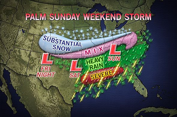
The temperature contrast will make for very challenging forecasts when determining which areas near the storm track will get snow versus rain. However, this stored energy can yield very dramatic results ranging from a foot or more of snow in some areas to a half a foot of rain with flooding and a severe weather outbreak.
Snow
The storm will gather enough cold air to begin producing a swath of heavy snow over parts of the central and southern Plains later Saturday and Saturday night. Parts of Kansas and Missouri appear to be in the middle of several different potential tracks at this time.
During Sunday, the band of heavy snow will nose eastward, most likely impacting some of the Ohio Valley states. A small shift in the storm track could mean the difference between heavy snow in Kansas City, St. Louis, Indianapolis and Dayton versus Omaha, Chicago and Cleveland.
By Monday, the zone of heavy snow will be impacting part of the central and southern Appalachians and could be aiming all the way to part of the mid-Atlantic coast and the I-95 corridor. Not only will the same challenges remain in the north-south orientation of the storm, but warm air from the Atlantic Ocean may play a role.
Severe Weather
There is the potential for severe weather to develop in portions of the Deep South from Texas and Louisiana to Mississippi, Alabama, southern Georgia and northern Florida with the storm system this weekend.
Humid air will nose northward along the Gulf Coast as the storm tracks eastward to the north.
According to Severe Weather Expert Henry Margusity, "Such a setup can deliver thunderstorms with large hail, damaging wind and perhaps a few tornadoes."
The exact character of the potential severe weather event (straight-line winds and hail versus tornadoes) is not certain at this time but will be monitored closely through the expected date by AccuWeather.com meteorologists.

This photograph of large hail and damage was taken in Pearl, Miss., on Monday, March 18, 2013, and is used with permission by an anonymous Facebook fan.
Flooding Rain
With the temperature contrast zone suppressed so far to the south and the potential for humid (very moist) air to surge northward into cool air, there is a risk of tremendous rainfall occurring south of the heavy snow area.
This zone will most likely occur over the interior South, beginning somewhere near the lower Mississippi River and shifting eastward with the storm track. However, it is not likely to be a brief event and can fire a day or two ahead of a dry sweep of air on the storm's southwestern flank.
"This means some areas could have rounds of heavy rain over a two- or three-day period beginning as early as Friday or Saturday in some locations," Margusity added.
While any non-disruptive rainfall would be welcomed in areas of ongoing or building drought from South Carolina to Georgia and Florida, it has the potential to get ugly.
The setup could bring low-lying and urban area flooding to significant rises on some of the rivers and will be monitored closely.
VIEW VIDEO
http://www.accuweather.com/en/weather-news/major-storm-potential-palm-sun/8440016