

Weather Channel Hurricane Specialist: 'All hell is breaking loose' 'Super-mega-combo freak of a storm slamming into most populated part of country' Sandy already one of biggest on record (PHOTO)
ENENews
Watch the most current satellite loop from NOAA here
Title: Sandy on Track – But Is the Message Getting Out?
Source: Bryan Norcross, Hurricane Specialist at The Weather Channel
Date: Oct 28, 2012

Hurricane Sandy (Source: NBC)
Sandy the super-unusual, combo hurricane/nor’easter on the unheard-of track is coming together as forecast.
[...] the focus on that energy is going to be on North Jersey, New York Harbor, and the south shore of Long Island. The National Weather Service in New York is predicting waves 10 to 20 feet high on the south-facing beaches. Holy crap!
Did I also mention that’s on top of the storm surge, which is forecast to raise the ocean level 4 to 8 feet above normal? And did I also mention that there’s a full moon and the storm’s peak is expected to be around high tide? Holy triple whammy!
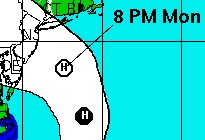
National Hurricane Center Forecast, 11p ET, Oct. 27, 2012
[...] the National Weather Service decided NOT to issue a Hurricane Watch for the Northeast coastline… are you ready for this… because it would be confusing to switch from that to a Coastal Flood Watch and a High Wind Watch after the storm – which will come ashore with hurricane-force winds – morphs into another kind of storm according to the meteorology dictionary. [...]
I grant that a technical reading of the “rules” says that you can’t put up a Hurricane Watch and a Coastal Flood Watch and a High Wind Watch at the same time. But I’m betting the rules didn’t envision a super-mega-combo freak of a storm slamming into the most populated part of the country. When all hell is breaking loose, sometimes you’ve got to break a few rules to do the right thing. [...]
The Oyster Creek nuclear power plant near Tom’s River, NJ appears to be at greatest risk for storm surge, as it’s located near the shoreline where the eye of the hurricane is expected to make landfall.