

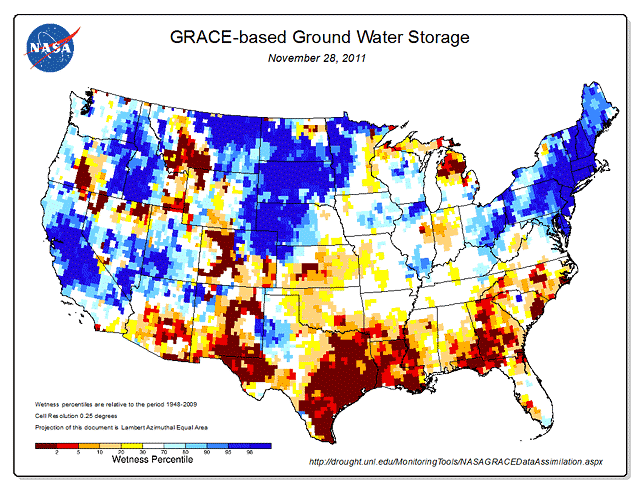
New US Ground Water Map Reveals Severity
New maps of groundwater and soil moisture produced by NASA are currently showing unusually low groundwater storage levels in Texas. The map color blue shows wetter-than-normal ground water conditions and a yellow-to-red color spectrum shows drier-than-normal conditions.
The latest groundwater map, released on Nov. 29, shows large patches of maroon over eastern Texas, indicating severely depressed groundwater levels.
The maps are distributed by the National Drought Mitigation Center at the University of Nebraska-Lincoln and are publicly available on the Drought Center’s website.
The record-breaking drought in Texas that has fueled wildfires, decimated crops and forced cattle sales has also reduced groundwater levels in much of the state to the lowest levels in more than 60 years…
The maps offer farmers, ranchers, water resource managers and even individual homeowners a new tool to monitor the health of critical groundwater resources.
“Over a long-term dry period, there will be an effect on groundwater storage and groundwater levels. It’s going to drop quite a bit, people’s wells could dry out, and it takes time to recover.”
Source: NASA News
States with an excess of ground-water
California, Idaho, Nebraska, North and South Dakota, Pennsylvania, New Jersey, New York, Connecticut, Massachusetts, Rhode Island, Vermont, New Hampshire, Maine
States with less than average ground-water
New Mexico, Texas, Oklahoma, Kansas, Louisiana, Georgia, North and South Carolina,
States that are borderline with less than average ground-water
Montana (southwest)
Colorado (west, south)
Arizona (south)
Michigan (northern, and upper-peninsula)
It appears that more than one-third of the US is lacking groundwater at this time, some areas quite severely.
Fresh water is becoming more and of a valuable commodity as time progresses and demands increase due to numerous factors including population expansion and industrial usage. Weather conditions of course will radically alter conditions over time, if persistent. a.k.a. drought.
Looks like the ‘blue’ states are ahead in the water department at the moment… thanks to mother nature.