

NYC, Mid-Atlantic Brace for Irene's Violent Strike
 For a larger version of this map and to view the current statistics of Irene, visit the AccuWeather.com Hurricane Center.
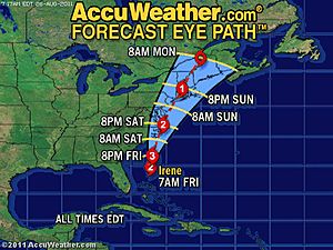
Irene remains on a path that will take the hurricane dangerously close to, if not over, the mid-Atlantic coastline and New York City Saturday night into Sunday, posing a serious danger to millions of people.
Irene could be "once-in-50-year" hurricane for the Northeast.
The AccuWeather.com Hurricane Center is confident that Irene will strike the Outer Banks of North Carolina on Saturday as a strong Category 3.
Beyond that point, Irene will track extremely close to or over the mid-Atlantic coast and New York City before plowing into western New England. This could mean the worst effects from a hurricane in the region in 50 years.
Irene is expected to track near the mouth of the Chesapeake Bay and Delmarva coast Saturday night, then could pass within 30 miles of New York City on Sunday as a weakening Category 2 hurricane.
Such a path would lead to severe impacts that has already prompted officials to force large-scale evacuations. All residents and visitors in the path of Irene should heed these orders and prepare homes and businesses for Irene's onslaught in the meantime.
"Numerous road, rail and runway closures are expected as Irene barrels north, underlying the urgency for residents to evacuate immediately," stated AccuWeather.com Meteorologist Bill Deger.
Aug. 26, 2011
VIEW VIDEO
http://www.accuweather.com/blogs/news/story/54098/hurricane-irene-to-slam-into-t.asp