

La Nina Pattern Means More Tornadoes and Thunderstorms Than Usual Likely This Spring
Jeff Alexander - The Muskegon Chronicle
The same weather pattern that delivered more than 8 feet of snow to West Michigan this winter will likely pound the region with more thunderstorms and tornadoes than usual this spring and summer, forecasters said.
A La Nina event, an unusual cooling of water temperatures in the Pacific Ocean, gave Michigan one of its worst winters in more than a decade. Now forecasters are predicting La Nina will spawn more severe thunderstorms, and possibly tornadoes, across the Midwest and lower Great Lakes region.
Though predicting the weather more than five days into the future is tricky, consider this: The last La Nina event, in 1998, spawned a fierce May storm that blasted West Michigan with 70 mph winds, toppling hundreds of trees and leaving 50,000 Muskegon County residents without electricity.
Marino said the La Nina event and a strong Madden-Julian Oscillation -- a weather pattern featuring thunderstorms and heavy rainfall that travels around the equator -- are expected to create "an unusually active severe weather season."
The National Weather Service is predicting an active tornado season for the Plains states and parts of the Midwest. Michigan is on the upper edge of the anticipated track of those storms; tornadoes are less likely to form in areas north of I-94 in lower Michigan, Marino said.
"The farther south you are in Michigan the more severe the storms will be," Marino said.
WOOD-TV 8 meteorologist Bill Steffen caused a stir recently when he predicted an active severe weather season and suggested Michigan is overdue for a major tornado.
"The last F4 tornado in Michigan was April 2, 1977, in Eaton Rapids," Steffen said on his blog. "Thirty-one years is a very long time to go without a tornado of that intensity in Michigan."
Steffen added: "I offer this thread not to scare you, but to make you aware that there are signs pointing toward an active severe weather season ahead."
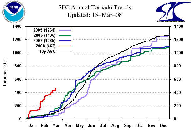
Photo: "La Nina events tend to favor an increase in severe weather," said National Weather Service meteorologist Bill Marino. "I would expect us to be above normal in terms of the frequency and coverage area of severe storms." (Flint Journal File Photo)
The National Weather Service's long-range forecast predicted average temperatures and precipitation in Michigan through June, with slightly warmer and drier conditions the remainder of the summer.
The Farmer's Almanac predicted temperatures that are slightly above average, and below average precipitation in Michigan in April and May. Summer temperatures will be one to two degrees below normal with below average precipitation, and September and October will be unusually warm, according to the almanac.
The greatest likelihood of severe weather is roughly from May 15 to Aug. 7, Marino said. Most tornadoes develop in the spring, when the contrast between warm and cold air masses is greatest.
Tornadoes are rare along the Lake Michigan coast compared to the rest of the state. The cool waters of the lake rob most weather systems of the heat needed to spawn tornadoes, Marino said. Once those storms move over land, they often pick up enough heat from the landscape to form tornadoes east of U.S. 131, he said.
"Tornadoes really don't like the lakeshore because the air is too cold over the lake -- the cold air chops the legs out from under storms," Marino said.
That doesn't mean West Michigan is immune to tornadoes. Muskegon County has recorded seven tornadoes since 1950; Ottawa County has had 18.
http://www.mlive.com/weather/index.ssf/2008/03/la_nina_pattern_means_more_thu.html
www.standeyo.com/NEWS/08_Earth_Changes/080324.more.tornadoes.html