

New List Ranks Driest US Cities; California Cities Hold Top 4 Spots
ABC Wisconsin
November 10, 2007
SoCal is the driest area in the United States and Texas is the wettest.
That's according to a new list from livability expert Bert Sperling that measures the drought severity for the 100 largest metro areas in the United States. Nearly 200 million people reside in these 100 metros, comprising nearly 60 percent of the U.S. population.
"This drought is having a deep and lasting effect on the choices regarding where we will want to live in the future," Sperling said. "The crisis has been growing slowly, but it is finally getting attention in the national spotlight."
sponsor
Topping the list was Los Angeles, with its recent annual rainfall only 25 percent of normal. The Los Angeles-Long Beach-Santa Ana metro area was joined in the top four spots on the list by other Southern California cities.
Coming in at No. 2 was the San Diego metro area, which includes Carlsbad, Calif., and San Marcos, Calif., followed by the Oxnard-Thousand Oaks-Ventura and Riverside-San Bernardino-Ontario metro areas.
Other top-10 driest cities include Salt Lake City, Nashville, Tenn., and Birmingham, Ala.
.jpg)
Image: Drought Conditions, National Climatic Data Center
At the other end of the list are cities suffering from too much water. Cities in the central Texas region such as San Antonio, Dallas, Houston, and Oklahoma City were afflicted by flood conditions this summer. Ironically, Sperling notes, these floods, which have caused deaths and property damage in Texas are the product of abnormal climate patterns that prevented the moisture-laden clouds to be carried northward to the already-parched Deep South.
NATIONAL DROUGHT EFFECTS
It's not just particular areas of the country that experiencing droughts. Sperling said the entire United States is in the middle of a nationwide drought, producing a crisis that some scientists believe will have greater consequences than rising sea levels.
The devastating brush fires in Southern California are one side effect of this continuing drought. The Deep South is also gripped by a prolonged drought, endangering the water supply for the 4.4 million residents of the Atlanta area.
The effects can also be seen in the shrinking Great Lakes, Sperling said. The historically low water levels are threatening shipping commerce, he said. The Florida Everglades are also being affected by Florida's continuing water emergency, he said.
"Brush fires in California, the shrinking Great Lakes, Atlanta's dwindling water supply –- these are some of the effects we're seeing today from our nation's drought crisis," Sperling said. "Water shortages are projected to increase as our population grows and a warming climate produces abnormal precipitation patterns."
MEASURING DROUGHT CONDITIONS
The study is based on the Sperling Drought Index, which Sperling created as a way for the public to easily understand and compare the severity of drought conditions.
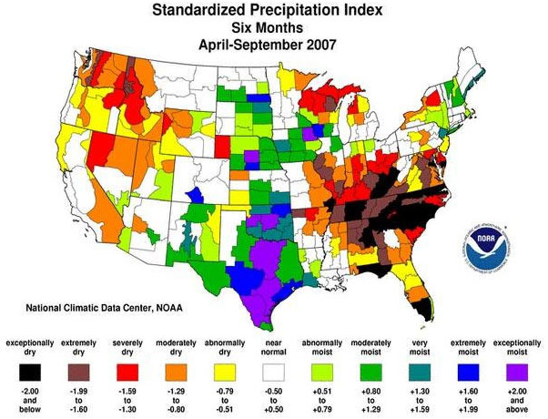
Image: Precipitation Map, National Climatic Data Center
Sperling has made a living for more 20 years through his firm "Sperling's BestPlaces" by helping people find their own "Best Place" to live.
"My work is all about measuring our livability and helping people find the best places for their life," said Sperling. I wanted to produce a metric that allows any city or neighborhood in the country to assess the current effect of the drought in their area."
The Sperling Drought Index is based on the scale where 100 represents the historic norm. Scores greater than 100 indicate drought conditions, and those less than 100 indicate abnormally wet conditions. Sperling and his team base the index on the latest drought and weather statistics from the National Climatic Data Center.
The complete database of Sperling Drought Indices have been put online, in a specialized Web site named www.DroughtScore.com.
DroughtScore.com is an example of a "micro-site", one of the newest trends in web design. Instead of a large site containing a wide variety of information, a micro-site focuses on a narrowly-defined subject.
Visitors to the site can assess and compare the drought risk for every city, town and zip code in the United States, representing more than 50,000 places in all.
In addition to the single score measuring the present drought situation in any area, DroughtScore.com graphs the scores for the last 13 months, comparing the local area to state and national averages.
http://www.wisn.com/weather/14555704/detail.html#
www.standeyo.com/NEWS/07_Earth_Changes/071111.driest.cities.html