
MASSIIVE INLAND OCEAN IN MOZAMBIQUE FROM TROPICAL CYCLONE SEEN BEFORE AND AFTER SATELLITE IMAGERY
Before-and-After Satellite Imagery of Mozambique
At a Glance
- Mozambique is experiencing massive flooding in the wake of Tropical Cyclone Idai.
- Satellite imagery is providing a new perspective on how widespread the flooding has become.
New satellite imagery is giving us a look at the scope of a massive flood, described as an "inland ocean" up to 30 miles wide in places, that has developed in Mozambique following the landfall of Tropical Cyclone Idai late last week.
Hundreds of people have died as a result of the cyclone and its flooding across Mozambique, Zimbabwe and Malawi, and officials there fear the total death toll will top 1,000.
Flood infrastructure has stood little chance, only exacerbating flood woes.
"We've never had something of this magnitude before in Mozambique," said Emma Beaty, coordinator of a grouping of NGOs known as Cosaco, AFP reports. "Some dams have broken, and others have reached full capacity, they'll very soon open the flood gates. It's a convergence of flooding, cyclones, dams breaking and making a potential wave: everything's in place so we get a perfect storm."
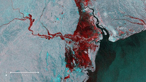
Cloud cover has prevented the ability to obtain a clear view of Mozambique using typical visible satellite imagery. However, special sensors on the European Space Agency's (ESA) Copernicus Sentinel-1 satellite can penetrate through the clouds to give us a view of the floods.
In the comparison below, you can see flooded areas (shaded black) in east-central Mozambique on March 19 compared to how it normally appears. The satellite view showing normal conditions was stitched together by using several images from earlier in March before the flooding developed.
(MORE: Latest on Idai's Impacts in Mozambique)

The ESA has provided an enhanced version of the same Sentinel-1 satellite image to make the floodwaters stand out from land areas. You can see the flooding in the red hues of the image below.
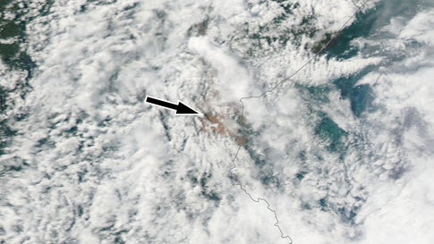
Even with thick cloud cover, we can still see evidence of flooding in typical visible satellite imagery, or how it would look when viewed by the naked eye from space. The black arrow points to the brown-tinted floodwaters in between breaks in the clouds in this NASA Modis satellite image from March 20.