
Through 8 p.m. CDT, storm total precip for Harris County averages 18". That more than all areas in red have received so far in 2017.

Custom Search
Rainfall from Harvey Could Reach 50 Inches in Spots, Highest Ever Recorded in Texas; Catastrophic Flooding to Continue for Day
Jon Erdman and Chjris Dolce8-218
8-28-17


Story Highlights
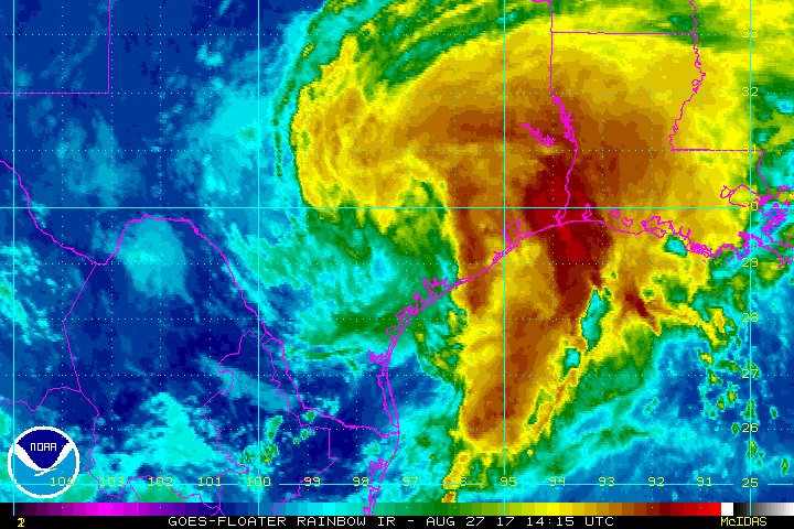
Tropical Storm Harvey is drifting back into the Gulf of Mexico and will meander near the upper Texas coast the next few days, bringing more torrential rainfall to the flooded Houston metro area, piling onto record-breaking, catastrophic flooding.
Localized storm total rain amounts of up to 50 inches are not out of the question once Harvey's rain is finished later this week. This may end up being one of the worst flood disasters in U.S. history.
Storm total rainfall in the Houston metro area, so far, from Harvey.(Data: NOAA/WPC, HCFCD)
Through early Monday, parts of the southeast Houston metro area had received more than 30 inches of rain since Thursday evening.
The average rainfall within the Harris County Emergency Management network has exceeded that of Tropical Storm Allison (2001) in almost half of the time (2 to 3 days versus 5 days).
The most rain from an Atlantic tropical cyclone or its remnants is 48 inches from Tropical Storm Amelia in 1978.
(MORE: Latest Houston Impacts)
Record flooding has occurred, and the flooding has rivaled what occurred in Tropical Storm Allison (2001) in some areas. Reports from the Harris County Flood Control District (HCFCD) and the National Weather Service include:
- Water levels on Cypress Creek near Interstate 45 will possibly top the levee by Monday morning, according to the National Weather Service. Residents in this area are encouraged to seek higher ground. The creek has already topped a record crest from 1949 near Westfield and from 1994 near Cypress.
- Spring Creek near Spring along the Harris/Montgomery County line, was expected to rise to the level that would top the Northgate Levee at Interstate 45 by over a foot Monday, also shattering a record from October 1994.
- Record flooding in Harris County has been observed at Brays Bayou, Upper Buffalo Bayou, Horsepen Creek, Little Cedar Bayou, Willow Spring Bayou, Armand Bayou, Turkey Creek, Beamer Ditch, Berry Bayou.
- Buffalo Bayou at Piney Point Village has already crushed a previous record from 1992 by over 6 feet and may crest over 12 feet above the record by Tuesday or Wednesday. The bayou has also topped a previous record from 1983 at West Belt Drive, expected to rise another 3 feet, there.
- Little Vince Bayou in the Houston suburb of Pasadena had reportedly equaled the level it reached during Tropical Storm Allison in 2001 early Sunday morning.
- The level of Clear Creek in Friendswood, Texas, exceeded what was experienced there during Allison by three feet Sunday afternoon.
- Devastating flooding was occurring on the middle and lower Clear Creek.
- Thousands of water rescues have occurred due to flooding in Harris County.
Houston's Bush Intercontinental Airport crushed its record wettest calendar day, Sunday, by over 5 inches, picking up 16.07 inches of rain. Houston's Hobby Airport also crushed a two-day rainfall record by almost 8 inches, picking up 23.06 inches of rain August 26-27.
Elsewhere, the Brazos River is expected to crest over 4 feet above the previous record set just last June atRichmond, Texas. Mandatory evacuations have been ordered in Fort Bend County.
Major flooding from up to nearly 22 inches of rain has also occurred to the east of Austin in Bastrop and Caldwell counties where water rescues have been reported. Record crests are expected on the San Bernard River near Boling and on Sandies Creek near Westhoff.
Still a named storm over 48 hours after landfall, Harvey is the longest a Texas landfalling hurricane hasremained a named storm after landfall since Fern in 1971, according to Colorado State University tropical scientist Dr. Phil Klotzbach.
Harvey made landfall Friday night near Rockport, Texas, north of Corpus Christi, as the first Category 4hurricane to landfall in the U.S. since Charley in August 2004.
(MORE: Hurricane Central | Latest Impacts | How You Can Help Victims)
The circulation from Harvey will meander near the state for several more days, resulting in additional double-digit rainfall amounts, potentially including Houston once again. Here's what to expect.
Still Days of Heavy Rain Ahead
The heaviest rain Monday, so far, has been in far east Texas and southwest Louisiana. Radar rainfall rates of 5 to 6 inches per hour were estimated in this band. Fourteen inches of rain flooded numerous homes near Hamshire, Texas. Water was also entering homes in Vidor, Texas, Monday morning.
Rain from Harvey is also continuing over parts of central Texas, and is extending into much of Louisiana and parts of Mississippi and southern Arkansas.
Current Radar, Watches and Warnings
Harvey's center of circulation is now moving offshore, triggering tropical storm warnings from Mesquite Bay to High Island, Texas.
(MORE: Harvey By the Numbers)
The tropical storm is currently caught in between two areas of high pressure and, without another weather system to scoop Harvey up, it will be stuck for the next few days before finally tracking north later this week.
The National Hurricane Center is not expecting significant strengthening of Harvey while it's briefly off the Gulf Coast, so the main concern should remain additional heavy rainfall.
Projected Path
The projected path shows the expected track of the circulation center. Note that impacts such as heavy rain and storm surge can extend beyond this forecast path.
A tropical cyclone's rainfall potential is a function of its forward speed, not its intensity. Therefore, several more days of torrential rain are expected in many of the already flood-ravaged areas.
Areas of heavy rain may persist in parts of Texas or the adjacent lower Mississippi Valley into Friday or Saturday, though the heavy rain threat will be gradually lessening in the most flooded areas by late this week.
(MORE: Water, Not Wind, the Deadliest Factor in U.S. Tropical Storms, Hurricanes)
Here are the latest rainfall forecasts through Friday from the National Hurricane Center and NOAA's Weather Prediction Center:
- Upper Texas coast into southwest Louisiana: an additional 15 to 25 inches, bringing isolated storm totals up to 50 inches over the upper Texas coast, including the Houston/Galveston metro areas
- Farther south into the middle Texas coast, west toward the Texas Hill Country and east across south-central Louisiana: storm totals of 5 to 15 inches
Rainfall Outlook
Areas in red, purple, pink and white are in the highest threat for flooding rainfall from Harvey through the weekend. Some of this rain may linger into Thursday or beyond in some areas.
Long-Lived Flooding
In addition to the reports mentioned earlier in this article, here are other locations that are forecast to experience river flooding this week.
Local National Weather Service offices have not minced words about the rainfall flooding, warning that some structures could become uninhabitable or be washed away. Roads and bridges could be closed, with some weakened or washed out, due to the record river flooding expected in some areas.
(MORE: Your Vehicle Can Be the Biggest Danger in a Flood)
The National Weather Service is forecasting major river flooding in roughly three-dozen locations in southeast Texas.
(MORE: NWS River Flood Forecasts)
Rivers forecast to be above flood stage by the National Weather Service River Forecast Centers, as of Monday morning, Aug. 28. Locations in major flood are denoted by purple dots, moderate flood by red dots and minor flood by orange dots. (NOAA/NWS)
Homes may be flooded along stretches of the Brazos, Colorado, Guadalupe, Navidad and San Bernard rivers.
Flooding along the Brazos River in Richmond, Texas, could exceed the previous record crest set just one summer ago, on June 2, 2016.
Much of the west and southwest sides of Wharton, Texas, could be under water from the Colorado River. The river may overtop levees by several feet in Bay City.
The Guadalupe River may flood parts of the city of Victoria. Upstream, the west side of the town of Cueromay experience disastrous flooding, potentially forcing all roads to be shut down into town except Highway 87. Near Thomaston, hundreds of homes may be flooded to over 10 feet, according to National Weather Service accounts of previous floods.
Given the longevity of the rainfall and floodwater draining from smaller tributaries, it's likely mainstem rivers such as the Brazos, Colorado and Guadalupe rivers will remain above flood stage into the Labor Day weekend, possibly beyond.
River Flooding After Surge Flooding
These floodwaters will drain toward areas near the middle Texas coast hammered by storm-surge flooding and destructive winds from Harvey's initial landfall.
Persistent onshore winds are still keeping water levels higher than normal along the middle Texas coast, including such areas as Port O'Connor and Port Lavaca. This coastal flooding may continue through multiple high-tide cycles the next few days, only slowly subsiding with time.
https://weather.com/storms/hurricane/news/tropical-storm-hurricane-harvey-rain-flood-forecast-texas-louisiana