

500 years of lies about the size of Africa
The Unhived Mind
The TRUE Size Of Africa – An Erroneous Map Misled Us For 500 Years!
MONDAY, APRIL 8, 2013
http://www.whydontyoutrythis.com/2013/04/the-true-size-of-africa-erroneous-map.html
Although featured in ‘The West Wing’, this map dishonesty is anything but fictional. The video below will give you an accurate look at the size of Africa.
People are often not aware of how large Africa continent really is. The image below is an accurate look at Africa relative to some major countries:
(SCROLL DOWN)
*
*
*
*
*
*
*
*
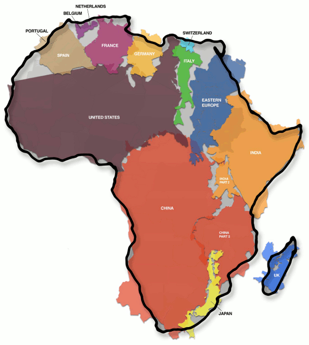
The map shows how Africa (30,3 million km²) is larger than the combination of China (9,6 million km²), the US (9,4 million km²), Western Europe (4,9 million km²), India (3,2 million km²) and Argentina (2,8 million km²), three Scandinavian countries and the British Isles (map gives no surface for these last two areas). Map Source
The Peters Projection World Map
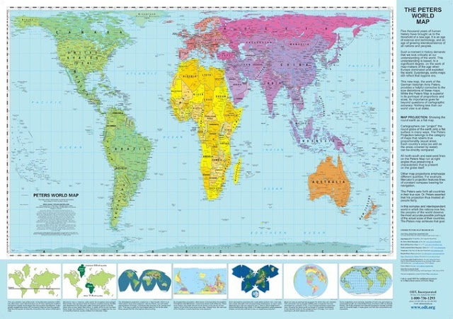
The Peters Projection World Map is one of the most stimulating, and controversial, images of the world. When this map was first introduced by historian and cartographer Dr. Arno Peters at a Press Conference in Germany in 1974 it generated a firestorm of debate. The first English-version of the map was published in 1983, and it continues to have passionate fans as well as staunch detractors.
The earth is round. The challenge of any world map is to represent a round earth on a flat surface. There are literally thousands of map projections. Each has certain strengths and corresponding weaknesses. Choosing among them is an exercise in values clarification: you have to decide what’s important to you. That is generally determined by the way you intend to use the map.The Peters Projection is an area accurate map.
A simple change in the look of a map can cause a reconsideration of your fixed ideas about a place.
http://theunhivedmind.com/wordpress3/2014/05/14/500-years-of-lies-about-the-size-of-africa/