Fukushima plume model shows 1 Million Bq/m2 over West Coast after reactor explosions — TV: Private emails reveal highest levels of gov’t worried about health impact in US — Nuclear industry tried to bury truth, while UC Berkeley experts told public “there is no plume” (VIDEO)
ENE News

Kamps appears to be referencing an ENENews report from earlier this month, Censored US gov’t emails reveal proposed plan to test West Coast residents for Fukushima fallout — “Many cases of cancer may end up being attributed to exposures” — Doses could exceed emergency levels
The report quoted internal emails from March 2011 by the head of UC Berkeley’s nuclear engineering department, who wrote: “UCB faculty [is in] general agreement that prompt action should be taken… Many cases of thyroid cancer, and other health problems, may end up being attributed to exposures from the Fukushima accident… on the U.S. west coast… It is possible that we will find that some people have received doses of I-131 and other radionuclides that could exceed the levels [which] Protective Action Guidelines are designed to prevent. It could identify individuals who have had significant exposure… alert them and their medical care professionals to monitor for potential health effects.”
On the Friday before UC Berkeley’s nuclear chair sent this proposal to a small group of government officials and experts, ABC’s San Francisco affiliate reported on public comments made by UC Berkeley’s nuclear department:
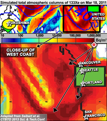
ABC (San Francisco KGO-TV), Mar 18, 2011: Nuclear engineers here at UC Berkeley say… don’t be alarmed. The tiny particles are just so small, they pose no threat at all… not harmful at all. One scientist here says you can get more radiation exposure on a flight… One model forecasts that the radiation plume… will reach California today… experts say this map is very misleading. First of all, there is no ‘plume’. Second of all, you cannot predict how the weather is going to carry radiation particles over here to the West Coast, if any at all.
The map above is a model developed by Japanese and European experts showing the strength and location of the Fukushima plume while over the West Coast on Mar. 18, 2011 — the same day as the broadcast of UC Berkeley’s claim that “there is no plume”. According to the map’s scale, dark red areas along the West Coast indicate the Fukushima fission product xenon-133 had a concentration in the air column of 1,000,000 becquerels per square meter.
Watch the interview with Kamps here
Published: June 24th, 2015 at 8:17 pm ETBy ENENews |
