

Japan sat on U.S. radiation maps showing immediate fallout from nuke crisis
Japan Times
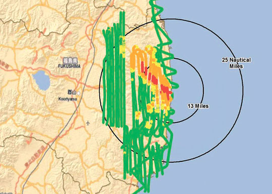
Fallout: Aerial monitoring results dated March 23, 2011, provided by the U.S. Department of Energy show that more than 125 microsieverts of radiation per hour were detected as far as 25 km northwest of the Fukushima No. 1 plant. KYODO
The government failed to make use of detailed U.S. maps showing how radiation spread shortly after the Fukushima nuclear crisis began, sources familiar with the matter revealed Monday.
The sources said the maps were neither publicized nor used to evacuate residents living near the poorly protected Fukushima No. 1 nuclear plant, which was racked by meltdowns and explosions after a massive earthquake and tsunami struck the area on March 11, 2011.
From March 17 to 19, U.S. military aircraft collected radiation data in an area with a 45-km radius from the plant for the U.S. Department of Energy. The data showed that more than 125 microsieverts of radiation per hour was leaking as far as about 25 km northwest of the plant, meaning residents in the area were being exposed to their annual permissible dose within just eight hours.
Before deciding to release the data on its own on March 23, the U.S. government provided the data via the Foreign Ministry to the Nuclear and Industrial Safety Agency — the regulator overseen by the Ministry of Economy, Trade and Industry — on March 18, and to the Education, Culture, Sports, Science and Technology Ministry on March 20, the sources said.