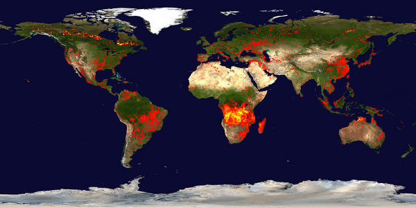
Global Fire Maps
http://rapidfire.sci.gsfc.nasa.gov/firemaps/
(SCROLL DOWN)
*
*
*
*
*
*
*
*
*
*
Fire Map (JPEG): 2048x1024 | 4096x2048 | 8192x4096
Fire Overlay Only (Gzipped GIF): 2048x1024 | 4096x2048 | 8192x4096
Static Links for Latest Fire Maps: Dates | 600x300 | 2048x1024 | 4096x2048 | 8192x4096
Each of these fire maps accumulates the locations of the fires detected by MODIS on board the Terra and Aqua satellites over a 10-day period. Each colored dot indicates a location where MODIS detected at least one fire during the compositing period. Color ranges from red where the fire count is low to yellow where number of fires is large. The compositing periods are referenced by their start and end dates (julian day). The duration of each compositing period was set to 10 days. Compositing periods are reset every year to make year-to-year comparisons straightforward. The first compositing period of each year starts on January 1. The last compositing period of each year includes a few days from the next year.
The About Rapid Response Imagery page provides more information on usage guidelines, product quality, and algorithms for the fire location data.
Fire location data:
MODIS fire location data are distributed in a variety of forms (e.g. interactive web mapper, GIS, Google Earth, text files) through the Fire Information for Resource Management System (FIRMS) at the University of Maryland. The official monthly MODIS active fire location text files are distributed from the University of Maryland via the FTP server fuoco.geog.umd.edu (login name is fire and password is burnt) in the directory modis/C5/mcd14ml. These data lag a few months behind the LANCE fire locations available from FIRMS. The fire detection code is identical to that used to process the official science quality data. However, there will be slight differences in the locations of the fires detected due to the geolocation differences caused by using predicted ephemeris.
Credits:
Fire maps created by Jacques Descloitres. Fire detection algorithm developed by Louis Giglio. Blue Marble background image created by Reto Stokli.
References:
Giglio, L., J. Descloitres, C. O. Justice, and Y. J. Kaufman. 2003. An enhanced contextual fire detection algorithm for MODIS. Remote Sensing of Environment, 87:273-282
Davies, D., Kumar, S., and Descloitres, J. (2004). Global fire monitoring using MODIS near-real-time satellite data. GIM International, 18(4):41-43
http://rapidfire.sci.gsfc.nasa.gov/firemaps/

